Excursion tip: Hike to Brunnenkopf & Linderhof Castle

For today, the weather forecast once again predicts perfect hiking weather. Accordingly, the hiking boots are put on again and the hiking backpack is packed. A new summit conquest is on the agenda. This time it will be up to Brunnenkopf (1,718 m) in the Ammergau Alps, from whose summit you can once again enjoy a breathtaking panorama.
Tour profile
Difficulty level: medium
Route length: approx. 11 km
ascents: 780 hm
descents: 780 hm

The starting point of the hike is the parking lot at Linderhof Castle. The journey time from Hotel am Badersee is approx. 45 minutes. In front of the parking lot, you pay the parking fee for the whole day (as of 2020: €2.40 for a car). After the bridge, drive on the far left to the farthest parking lot, because this is where the hiking trail starts.
A hiking sign shows the direction of walking and also the approximate time it takes to climb. 2 hours and 15 minutes. Hmm, my companion said it would only be easy 1:30 hours. Who do you think I should believe now? But no matter how long it takes at the end, I always say “The journey is the destination”, what counts is to enjoy the hiking tour and to enjoy nature along the way. But I already assume that I need more than 1:30 hours. Today he is finally traveling with me and he just has to wait there if necessary.
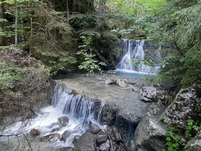
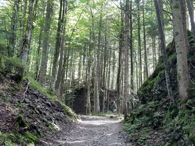
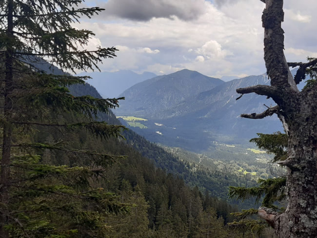
We dive past rushing water with landscaped waterfalls into the forest. In the shade of trees, we now climb the mountain one bend after the other on a wide path. At first, there is nothing to see from the summit or some initial views, the forest is thick and barely allows you to look up or out.
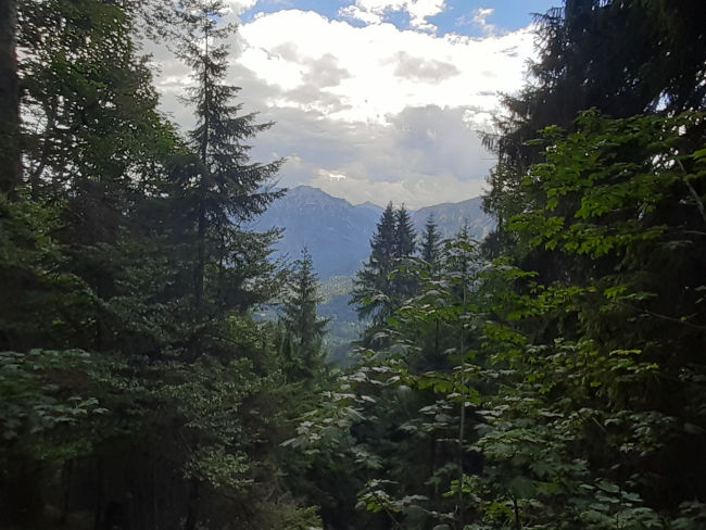
I wonder how many bends we've climbed up by now. On the way back, I should maybe count the hairpin bends once again, because I feel as though I've already run an infinite number of corners. But in the end, we reach the first altitudes and the forest clears out from time to time so that we can now see the horizon. At a fork in the road, from which a hiking trail branches off to the right to Pürschling, there is an opportunity to rest on the left without much hustle and bustle. There is no bench here, but there is a small rocky outcrop with a view. Since we don't know how many hikers are already resting at the Brunnenkopfhütte, we take the opportunity to take a break here, have a drink and enjoy the view. And as it should be, we have this space all to ourselves.
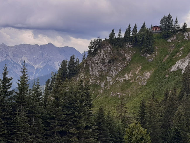
It's time to tackle the last stretch of the road. Now it is not far to Bunnenkopfhütte (1,602 m), which we can see perched on a mountain ledge after a few hundred meters high. With the goal already in mind, the last steps are easier - admittedly, the break before has also made running a bit easier again. Once at the top of the hut, our previous idea is confirmed that the hut may already be well visited. It's good that we took our break beforehand, because all seats in the popular hut are currently occupied.
So we don't stop for long, but set off to climb the summit. The last stretch to the summit is really tough, because the trail is steeper than before, the muscles start to burn and the heartbeat rises rapidly. But the will prevails over all the pain I feel in my legs right now. I want to force the summit and stand at the summit cross. So take a deep breath on and off you go.

Shortly before the summit, we have to wait for a few returnees, because the last stretch to the summit is only via a via ferrata and a narrow path that is not made for many people at once. When the group passes us, we have the way clear. A tensioned rope on the rock ensures a secure grip up to the summit. This section of the via ferrata is not difficult, but anyone who is afraid of heights should stop first and simply enjoy the mountain panorama on the last few meters of altitude. We, on the other hand, climb up and now have the summit to ourselves for a few minutes. There must also be an entry in the summit book, then we will leave the summit to the next hiker, because there is no space here in this tight space.
Follow the same route from the summit back down to Brunnenkopfhütte. While the climb was difficult before, it's easy and flaky downhill again. I wish it would be the other way around. Unfortunately, the hut is still full, so we decide to return to our previous rest area. On the way back, we'll be back here enjoying our lunch and a cool drink. This is followed by the descent down to the car park. Halfway through, I remember that I wanted to count the bends after all. What a bummer, running back is definitely not an option, maybe next time I feel like climbing the summit again. The descent is of course quick again and after an hour we are back at the parking lot. If we are already at Linderhof Castle (937 m) and the weather is still at its best, then we want to take a walk through the castle park. There is still a stop at the entrance to the park and here we treat ourselves to a delicious piece of cake and an iced coffee.
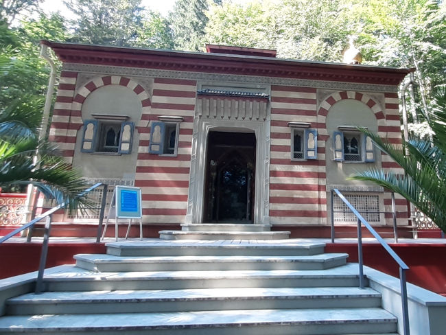
The calorie bombs we have just taken with a clear conscience now have to work something off again and so we set off to visit the castle park with its numerous royal buildings. Our first stop takes us to the Moroccan House, which Ludwig II bought at the 1878 World's Fair in Paris and had the interior decorated according to his wishes.

Passing by the swan pond, unfortunately there was no sign of a swan today, we reach the favorite castle of the Bavarian fairy tale king. Of course, we won't miss the opportunity to walk up to the pavilion, from which you can see the full extent of the palace complex.
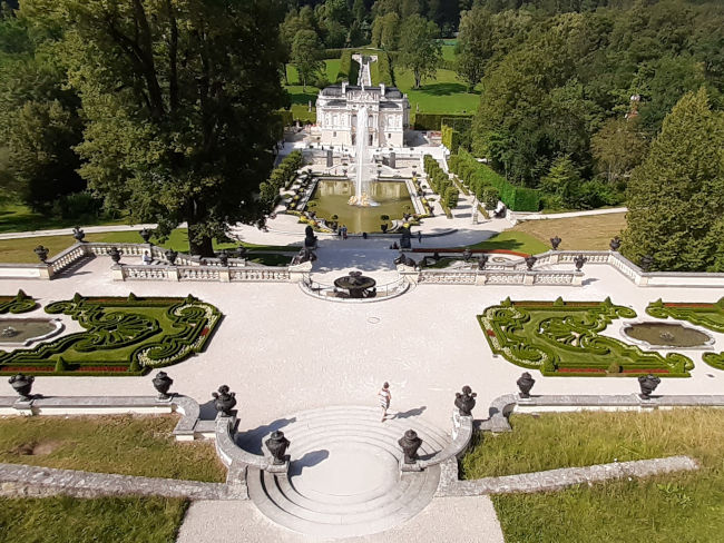
By the way, anyone who wants to visit the castle from the inside should do so. Ludwig II was a real romantic and his decor was quite extravagant and exclusive. A guided tour of the small pretty palace takes around 30 minutes and is definitely worthwhile. Our tour takes us past the Russian chapel and the Moorish house. Then we've walked enough for the day and now we prefer to relax on the balcony and just look at the mountain peaks with our eyes.
A next tour in this area is definitely being planned, as there are a few more trails from the Linderhof Castle car park through the fantastic landscape, which King Ludwig II loved so much that he enjoyed staying here.
Tips & info:
- Walking time: between 3:30 — 4 hours; ascent approx. 2:00 — 2:30 hours, descent approx. 1:00 — 1:30 hours, almost 800 meters in altitude
- Easy to moderately difficult hike depending on physical condition, mostly on moderately inclined trails.
- Mountain summit: Ascent secured by a steel cable. Sure-footedness is required. The place on the summit is very small, it is better to wait until previous visitors have come down from the summit again before you go up yourself.
- Bring good hiking boots, appropriate clothing & equipment depending on the weather
- Arriving by car: From Hotel am Badersee via B23 and B2 to Oberau, then follow the B23 towards Ettal, Oberammergau. Junction at Linderhof Castle behind Ettal to the Linderhof Castle car park.
- Places to stop for refreshments: Brunnenkopfhütte: Check opening times! Linderhof Castle car park: there is a small kiosk here with snacks (chocolate bars, pretzels, sausages), popsicles and drinks, open all year round except for occasional holidays. Entrance to Linderhof Castle Park at the souvenir shop: here Are there cakes, ice cream in style, iced coffee/iced chocolate, sandwiches and 2-3 hot dishes. Open all year except for occasional holidays.
- Schlosshotel Linderhof remains closed due to renovation work (as of 08/2023).
- Visit to Linderhof Castle park free of charge, guided tour of the castle for a fee - more information here.
Heartily Wellcome
at Lake Badersee