Excursion tip: winter hiking on the Notkarspitze

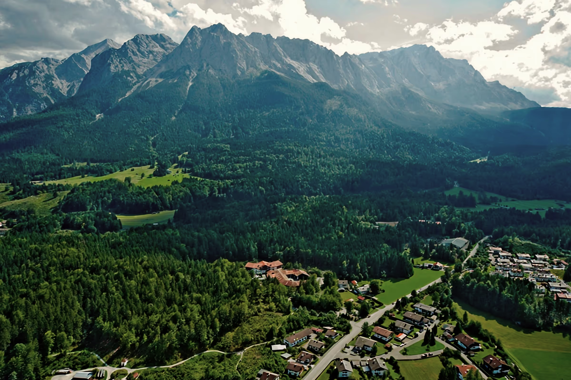
With its altitude of 1,889 meters, great panoramic views and numerous hiking routes that offer varied mountain tours in almost any weather, the Notkarspitze is one of the most beautiful day destinations in our area.
Tour profile
Difficulty level: difficult
Route length: approx. 18 km (total)
ascents: 1,350 hm
descents: 1,350 hm
The versatile Ammergauer
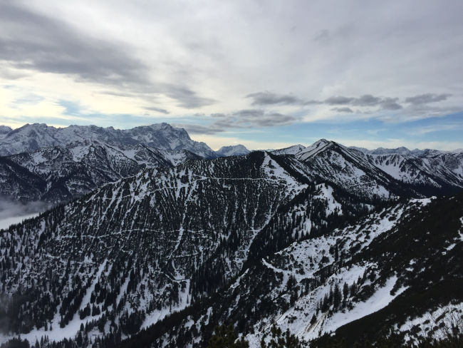
The Notkarspitze is located in the Ammergau Alps between Garmisch-Partenkirchen and the Graswang Valley. The mighty mountain ridge with all its peaks in Partenkirchen is easy to spot when the weather is nice. From the mountain summit, a wonderful alpine panorama opens up in every direction, and the villages in the valley such as Garmisch-Partenkirchen, Oberammergau, Ettal and Graswang are also clearly visible. On sunny days, the flat ridge at Ziegelspitz offers great opportunities for a high-alpine picnic at an altitude of 1,700 m.
The Notkar massif includes a total of three peaks: the Ochsensitz (1,515 m), the Ziegelspitz (1,719 m) and the Notkarspitze (1,889 m) — i.e. three summit crosses in one day! In addition, at least four official hiking routes lead to the Notkarspitze:
- from Ettaler Sattel via Ochsensitz and Ziegelspitz to Notkarspitze summit (Route 264)
- from Ettaler Mühle via Notkar to the summit (Route 262)
- from Graswang/Dickelschwaig via Kühalm to the summit (Route 263)
- from Garmisch/Burgrain/Farchant via Reschberg/Rossalm to the summit (several trails or route markings)
The routes can be wonderfully combined, e.g. ascent from Ettaler Sattel and descent to Ettaler Mühle, or a big crossing from Graswang to Garmisch/ Farchant is also possible. A bike trip with a visit to the summit can also be made easy for experienced mountain bikers: for example, with a start on the Ettaler Sattel via the forest road (Route 265), a summit climb from the Rossalm (on foot) and finally a rapid descent to Burgrain. Another advantage is easy access by public transport (see our tips & information below).
Winter hiking on the Notkarspitze
Route 264 from Ettaler Sattel to Ochsensitz offers the opportunity for winter hikes. The risk of avalanches on the route is relatively low due to its moderate slope, and the trees also protect the slope. From Ochsensitz, you can continue to Ziegelspitz or even to the Notkarspitze summit under suitable weather conditions and good visibility. However, there are several meters of deep snow on the ridge between Ziegelspitz and Notkarspitz in winter, meaning that you can barely get anywhere without snowshoes. In addition, you have to watch out for snowdrift or snowdrift near the ridge, which can come off at any time. From Ziegelspitz, winter hiking is therefore only recommended for experienced mountaineers.
Alpine hazards. Although Route 264 is relatively safe, Notkarspitze is considered the most dangerous mountain in the entire Ammergau region, as most accidents occur here. This is partly due to the fact that there are many unmarked trails in the Notkar Massif. It is therefore extremely important to stay on the marked hiking routes. It's sometimes not that easy in winter: it's easy to get lost in the snow. Especially in the ridge area, the wind blows its tracks within a few minutes, and when visibility is low in fog, you lose your orientation and can suddenly end up in a danger zone where you can no longer get out. Route 262 (from Ettaler Mühle) is not accessible in winter due to the risk of avalanches. The times in the blog are for experienced mountaineers. Take note of our Tips for snow hiking.
Snow hike from Oberau to Notkarspitze
As an Oberauer, I can call Notkarspitze my local mountain. Not only do I see its peaks from my south-facing balcony every day, but I also enjoy walking the various routes. I also use the Notkarspitze as my everyday training route in winter: Route 264 usually goes without avalanche equipment, which is a big advantage in winter. It is only 650 m from Ettaler Sattel to Ochsensitz, but I usually start directly from Oberau, so it's about 1,300 m to the Notkarspitze summit - perfect as a day exercise.
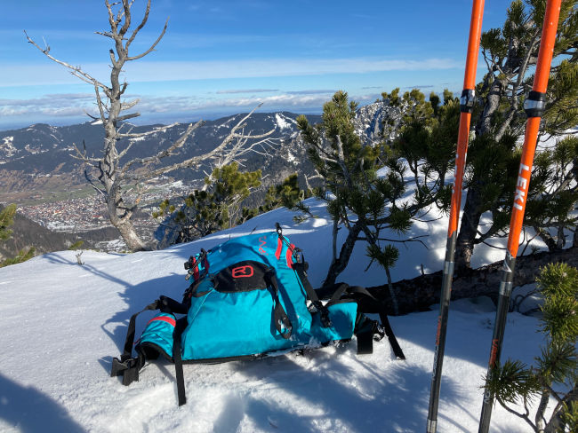
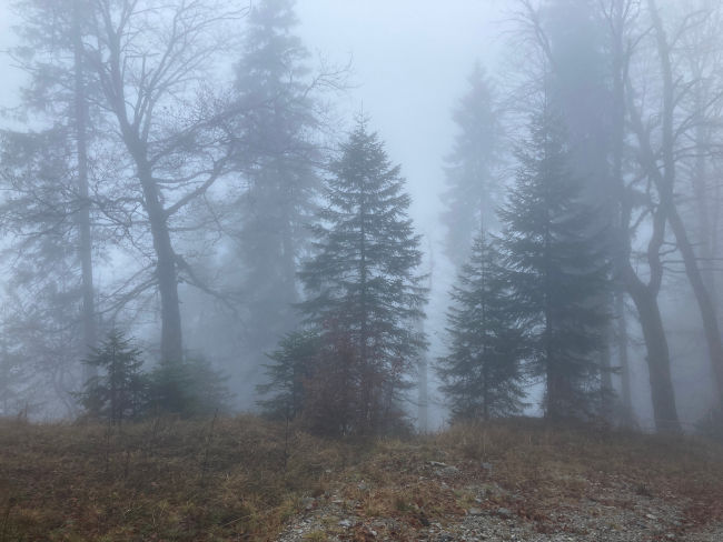
09:00 o'clock: Saturday morning is still gloomy with sleet and fog, but I still opt for a short mountain tour, especially as the weather forecast is positive. In addition, the movement is always worthwhile. So I pack up my hiking sticks and thermos, I also take the Grödel, leggings for deep snow, warm clothes including a second pair of gloves, lights and a few snacks. I cycle through Oberau to the starting point of my hike: the small bridge on Alte Ettaler Straße. From here, walk up the historic road.
The easiest way is to follow Alte Ettaler Straße directly to the point where it crosses the B23 at the top of Ettaler Berg, and then follow the country road to the left to the Ettaler Sattel car park. However, you have to walk on the side of the road for the last 150 m, which is sometimes not entirely harmless in a road bend with limited visibility. That's why I use the small path through the Giessenbachrinne, which starts on Alte Ettaler Straße. Shortly after the “Kienjoch-Rundweg” junction, the next branch to the left, which is not marked. Here I leave Alte Ettaler Straße and reach an old power plant after a few minutes. The narrow path then continues, crosses the stream and takes me left on a big bend until I reach a forest road that leads uphill to the Ettaler Sattel car park. Just before the parking lot, the trail turns left again and takes me straight to my hiking trail. The trail also has disadvantages: after a storm two years ago, there are still numerous fallen trees along the way that have not been removed to this day. So I always see the trail as an entry-level trail - after climbing over tree trunks, you arrive at the Ettaler saddle well warmed up and already fit.
09:45 o'clock: The first climb comes directly from the parking lot, which takes me across the wide forest road to the starting point of Route 264. The first sign to Ochsensitz/Notkarspitze is clearly visible and the popular trail is easy to spot in the forest. The first 500 meters go through the mountain forest and are pretty boring. The ascent is relatively easy; only at an altitude of around 1,300 m are there a few steeper rock sections.
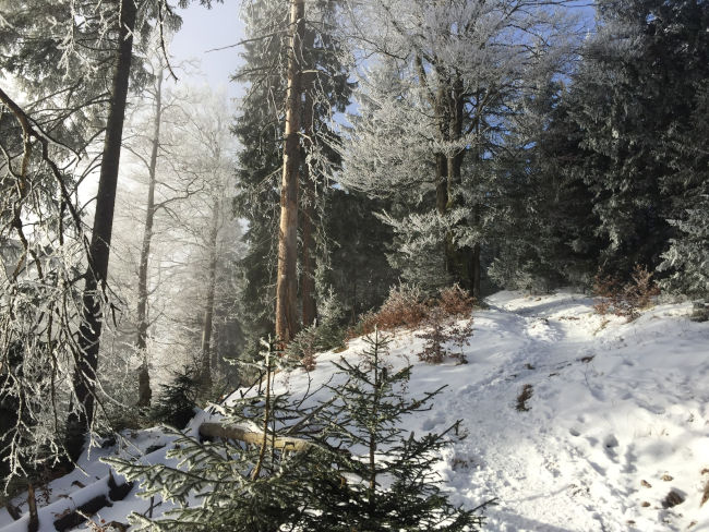
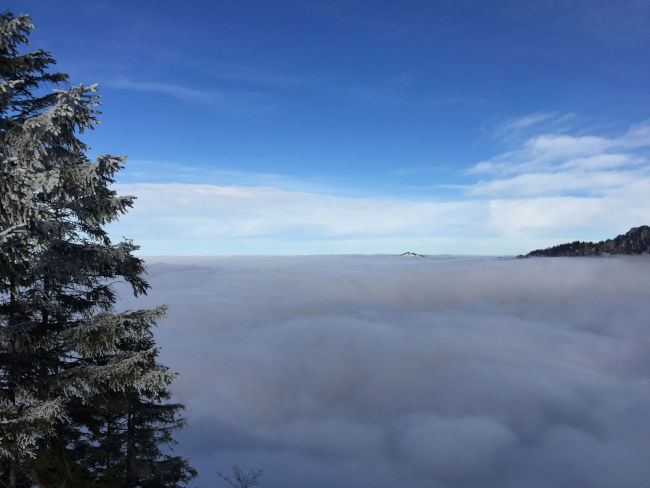
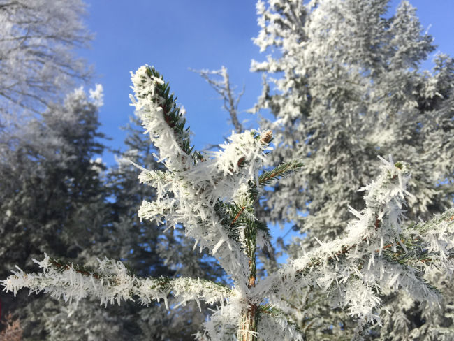
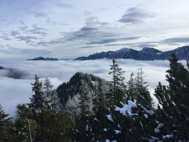
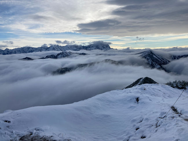
10:30 a.m.: The drizzle and thick fog are slowly giving way and wonderful sunrays are now cutting through the seemingly sleeping mountain forest. It also gets noticeably colder from here on. The trees are decorated with fairytale ice crystals. I reach a clearing below Ochsensitz. When the weather is nice, from here you have a great view of Ettal with its monumental monastery and Oberammergau, crowned with the Kofel. Today, however, you only see an endless field of fog, from which the surrounding mountains look out.
But there is a warm sun up there and it was worth it again to go hiking in the initially bad weather. The panorama is unbelievable and I spontaneously decide to take the “complete” hike up to the Notkarspitze summit to enjoy the great time of the sun.
10:45 o'clock: After a short photo stop at the Ochsensitz summit cross, it's straight to Ziegelspitz. From Ochsensitz, the trail first leads slightly downhill. Here, the trail runs through thick spruce trees, which stand sporadically on the cozy broad ridge covered with grass. Pale lichens hang on their branches, creating a very special atmosphere in high alpine mountain forests, as if you were being transported back in time to the century when nature was still beneath itself. The warm rays of the sun are reflected by the snowpack. The air becomes warm and pleasant, so that when you inhale, you can taste the sweet aftertaste of mountain pines on your tongue.
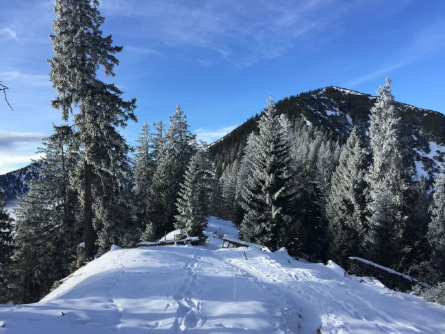
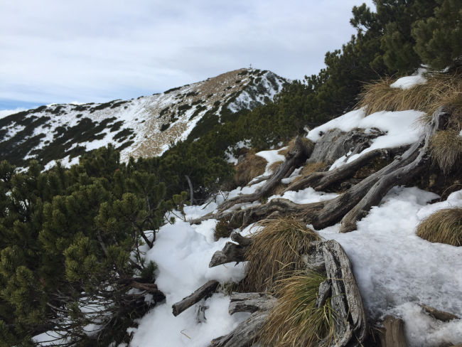
But now it's up towards Ziegelspitz. The steep path snakes through pine trees, of which only individual branches can be seen in the snow right now. There is significantly more snow here on the ridge than below the Ochsensitz. In summer, the mountain pine growth at this point is significantly higher than 2 meters, so you can imagine the amount of snow the plants have to reckon with here.
11:15 a.m.: After about 30 minutes, I am at the summit cross on Ziegelspitz. At the top, the sky is slightly cloudy again, but the fog below is no longer as thick, you can already see individual houses in Graswang and in the back of Oberammergau. I'm going 100 m further and looking for a sunspot for a leisurely break with a view of Garmisch-Partenkirchen and Oberammergau, which are just slowly freeing themselves from the fog. It has become so warm that you don't feel like getting up anymore after 15 minutes in the sun. However, I still want to get to the summit of Notkarspitze. I'm putting the thermos back in my backpack. There are almost no hikers on Notkarspitz today: the trail leading towards the summit definitely belongs to just one person.
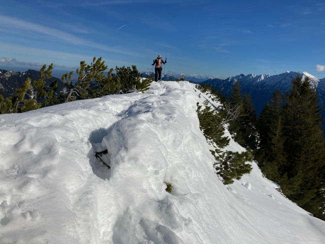
I follow the trail and find out shortly after that, with every further step, I sink down to my hips into the snow. This makes hiking no longer fun. I also notice that I am currently standing in snowdrift, which can slip off at any time. It's hard to get to the side where the snow is even deeper, but it's a bit safer here. Five more steps and my feet won't sink anymore. I am (probably) slowly returning to the route that now takes me on a steep climb to the intermediate summit, which is still on the way to Notkarspitze.
12:15 p.m.: From here, it's time to descend about 30 meters in altitude again until it goes steeply up to the summit cross again. The ridge is very narrow at this point and is always icy in winter. The abyss looms to the right of the ridge, so be careful! There is a strong wind blowing from the Graswang Valley, so that with some gusts I have to crouch behind the small layers of snow that were blown in here during the snowfall tonight. Now I am met by the hiker who had groomed the trail - the only person I meet on the mountain today. It's very windy up there, he says.
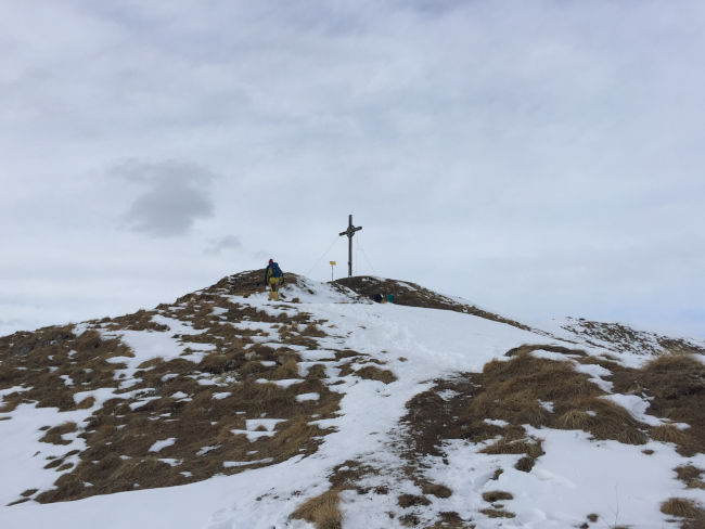
12:30 p.m.: But that doesn't matter, there is no picnic planned at the summit cross. The goal has been achieved, so I'm on my way back after a few seconds - looking for slipstream for now. The descent from the summit is icy, you have to climb down here carefully, the hiking poles are difficult to use.
1:00 PM: In strong winds, the trails left by the hiking colleague almost disappeared after just under 20 minutes. But it is bright and I know my way around the track. This is how I will reach Ziegelspitz again shortly. From here, the gaiters and groedel are used and it goes down quickly. In just under 45 minutes I reach the Ettaler Sattel and around 3 pm I am back home in Oberau. Now I'm looking at the mountains again from my balcony and I'm looking forward to a successful hiking day.
conclusion
Depending on your fitness level, this moderate hike can be done in various variants. The best thing about it is that you can determine the length of the route yourself and turn around at any time. The route between the Ettaler Sattel and Oschensitz (650 m) or to Ziegelspitz (850 m) would also be suitable for less experienced hikers. This section is also recommended as a snow hike in winter.
Tips & info:
- Route length: approx. 10 km circular hike (from the Ettaler Sattel and back)
- Altitude difference from the Ettaler Sattel: 650 hm (to Ochsensitz), 850 hm (to Ziegelspitz) or 1,050 hm (to Notkarspitze)
- How to get there from the hotel am Badersee: by train or Eibsee bus to Garmisch, then by regional train to Oberau. From there, take bus 9606 to Ettal. If you are more fit, you don't have to wait for the bus in Oberau, but can get on foot from Oberau to the Ettaler Sattel (+ approx. 200 hm/+4 km in each direction). Alternatively, you can get off in Farchant and hike across the Reschbergwiese from Burgrain to Rossalm. From here, you can climb directly to the Notkarspitze summit - the Ziegelspitz and Ochsensitz will then fail. Of course, you can also descend to the Ettaler Sattel via Route 264 and take the two smaller peaks with you.
- Arriving by car: Enter the Ettaler Sattel car park as the destination in the navigation system (subject to a fee). The car park is often filled quickly when the weather is nice, or you can park in Ettal at the Kloster Ettal/Schaukäserei car park (subject to a fee).
- Places to stop for refreshments: None on the route, i.e. bring enough drinks and food. There are numerous restaurants in the neighboring villages.
- Alpine hazards: Please note the correct equipment and our safety instructions for winter hikes: Alps “for Dummies” - safety in the mountains for beginners in winter
Heartily Wellcome
at Lake Badersee