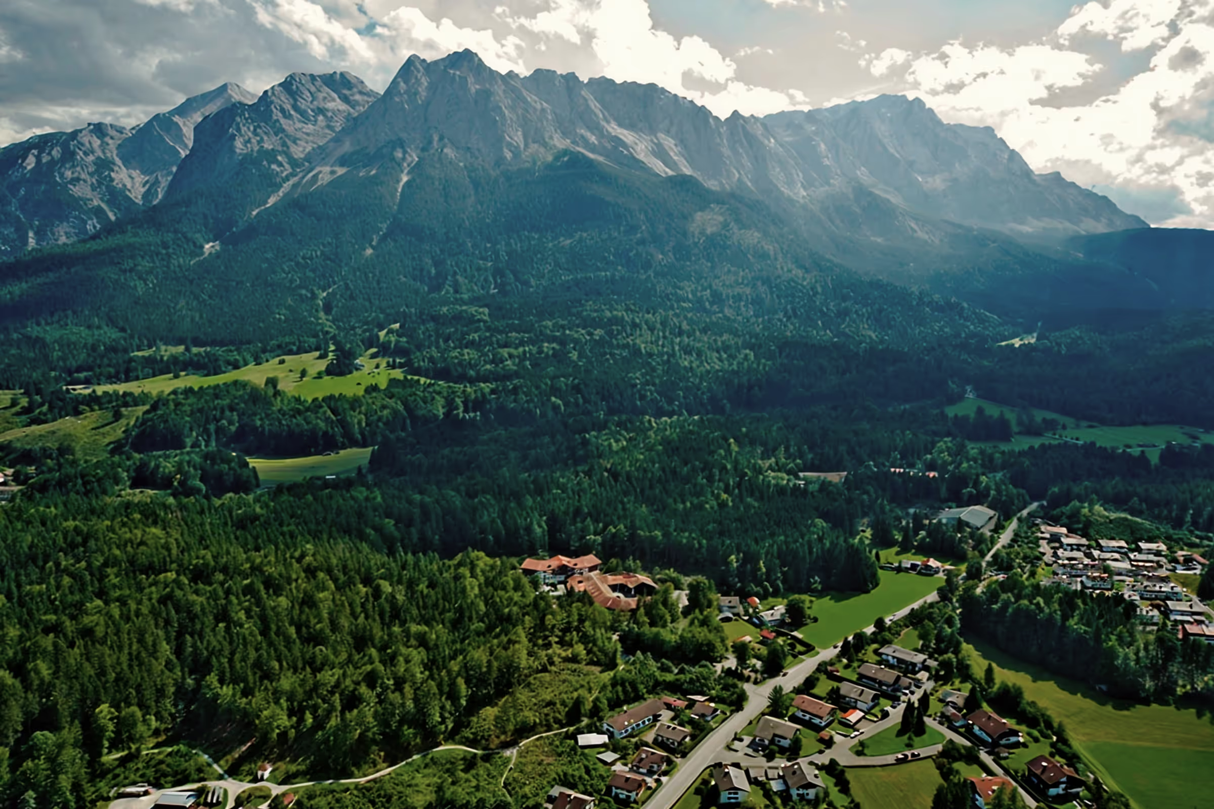
A perfect day in Grainau: Climbing the Alpspitze part 2 — circular hike across Höllental, Matheisenkar, Alpspitze & Schöngänge

Climbing the Alpspitze (2,628 m above sea level) is possible in summer via several routes. Depending on how many meters in altitude you want to overcome, there are numerous opportunities for hikers at the Alpspitze to extend or shorten the routes and diversify them with side activities. Starting at Kreuzeck, in Hammersbach, at the Hausberg or even in the Partnach Gorge, mountaineers have a dozen options to reach the popular summit.
Since the selection is so wide, we describe two routes here in the Badersee blog — a moderate tour for beginners with previous knowledge and a difficult tour for experienced mountaineers. At around 600 m, the popular Alpspitz-Ferrata (via ferrata A/B) is considered the easiest route on the Alpspitze. And the challenging (2,100 m) circular hike from Hammersbach via Höllental, Matheisenkar (via ferrata B/C), Alpspitze peaks and beauties (via ferrata A/B) makes the heart of an experienced mountaineer beat faster.
Part 1: Climbing the Alpspitze via the Alpspitz-Ferrata
Alpspitze for advanced skiers: circular hike across Höllental, Matheisenkar, Alpspitze & Schöngänge
Tour profile
Difficulty level: difficult
Route length: approx. 22 km
ascents: 2,100 hm
descents: 2,100 hm
This dream tour for ambitious and experienced mountaineers starts in Hammersbach. On the Stangensteig trail, it goes into Höllental, then from the Höllentalangerhütte to Matheisenkar. The via ferrata takes you to the Grießkarscharte and on to the Alpspitze summit. From the summit cross, it then descends over the east ridge to the Bernadeinsattel and on the Schöngänge via ferrata to the Hochalm. The descent is from Kreuzeck on the Jägersteig back to Hammersbach.
The times in the text can be used as a reference for experienced mountaineers. Less experienced mountaineers should refrain from taking this tour and should choose an easier route. The tour is only available from mid-June to October and weather permitting. For this tour, it is particularly important general safety tips for mountaineers to note.
10.00 a.m.: When the weather is nice, the traffic situation in Garmisch is sometimes very tense on weekends, so I cycle to Hammersbach. Here it starts on the normal route towards Höllentalklamm - to the first fork, where most hikers turn left to the entrance to the gorge. For me, I turn right towards “Höllentalangerhütte via Stangensteig”. We have the Stangensteig in the Badersee blog already described: In high season, it is a good alternative to the Höllentalklamm gorge for those who have already visited the gorge and want to avoid large crowds of people. The Stangensteig is also free of charge. It has an altitude difference of about 200 to 250 meters more than the normal route and requires a bit more sure-footedness.
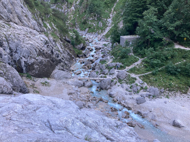
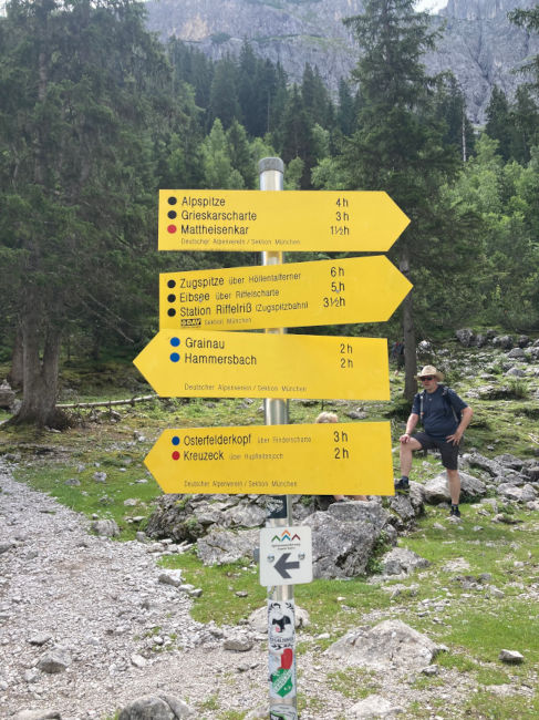
11:30 a.m.: After about 1.5 hours I reach the Höllentalangerhütte (1,387 m). The short route to Matheisenkar starts directly from the hut — the signpost can be found at the bridge. The route is partly a rope-protected via ferrata B/C, which ends at the top of the Grießkarscharte (2,463 m). The walking time shown on the signs is 3 hours.
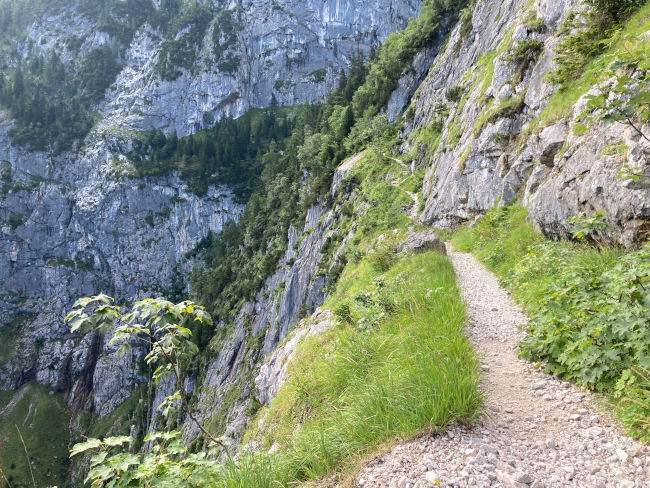
After a drinking break, it continues. The route is generally less known than many other tours in Höllental and is mostly used as a descent route from the Alpspitze and Jubiläumsgrat. However, it is highly recommended when climbing. The picturesque high valley side above the hut is a small paradise with rocks, mountain pines and alpine plants. And even though the ascent to Matheisenkar is extremely steep and sweaty, the upper flat section is all the more rewarding before you enter the bare Kar area.
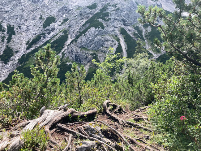
1:30 p.m.: The rocky trail becomes increasingly gravel and I reach the start of the via ferrata. The starting point is at the foot of the rock face and is clearly visible. I put on my harness and the walking sticks are put in the backpack until further notice. At this point, you can secure yourself directly on the wire rope, but after a few meters, the route becomes a bit flatter and even more rugged, so that there is no longer any rope protection and the harness is no longer of any use. You have to freely climb through the terrain for over an hour. On the rest of the route, I am met by many hikers who have climbed the Alpspitz-Ferrata on the first mountain railway and are just about to descend into Höllental. The route is getting steeper and the rocks are no longer as brittle. The top 300-400 m are again secured with a rope. Climbing is a lot of fun here and the view of Höllental and the surrounding mountains is breathtaking.
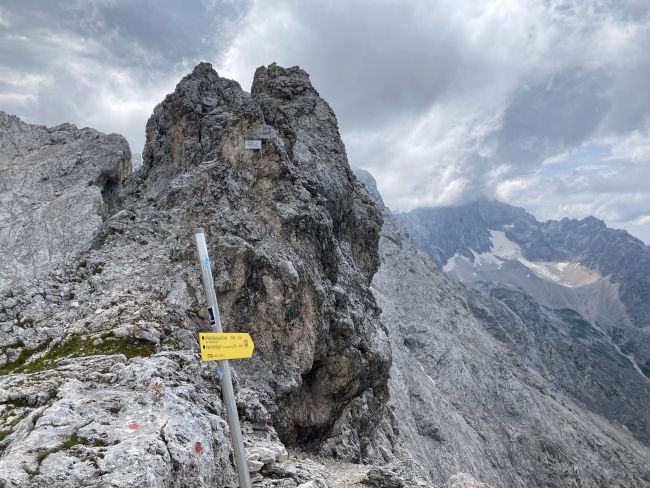
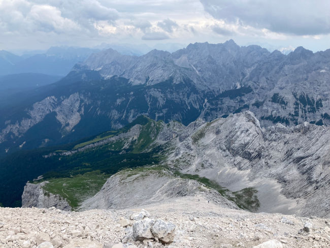
3:15 p.m.: After the last corners secured by rope, I reach the Grießkarscharte. Here I treat myself to a longer break and a snack before continuing on to the windy Alpspitze summit. A mouse and an alpine jackdaw keep me company and are rewarded with an apple bum, bread crumbs and some nuts. The Scharte is located on the famous Jubiläumsgrat — the historic high-alpine route that was built at the beginning of the 20th century between the Zugspitze and the Hochblassen. From here, it is still about 150 meters in altitude to the Alpspitze summit, which I will soon reach on an easy, unsecured via ferrata (A/B).
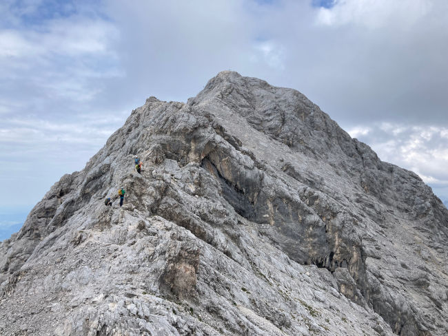
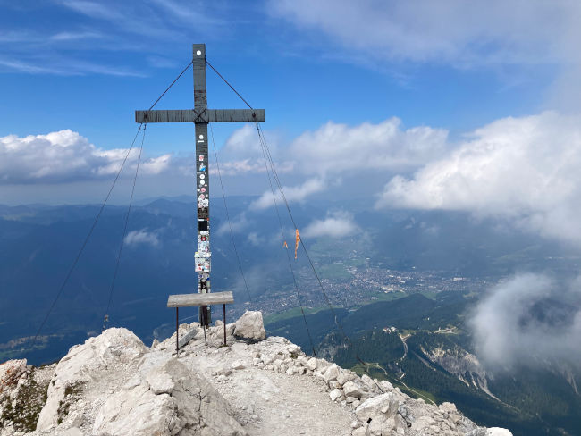
4:15 p.m.: The Alpspitze typically greets you with a strong summit wind and its moon-like landscapes. Although visibility is above average today, a break at the summit cross unfortunately makes no sense again. After I have reached today's highest point of my hike here at an altitude of 2,628 m, I put on a warm windbreaker, get my walking sticks out of my backpack and off I go down into the valley.
The descent for me today is over the North Ridge. It goes steeply and pathless through the gravel until I reach the first Schrofen after approx. 200 m. It's very easy to lose the route here. You can see numerous tracks that run systemlessly from the North Ridge to the Oberkar. It's not necessarily dangerous in summer, but it's not ideal from a tour planning point of view. The normal route on the ridge is time-saving and even offers secure routes. Finding your own way through the rugged wall takes a lot of time and effort.
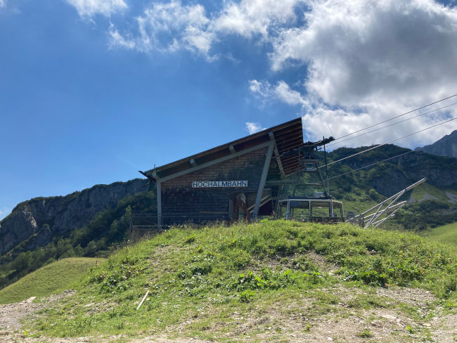
5:15 p.m.: At Oberkar, the many roads come together again. Here you reach a signposted fork. Continue straight on the Nordwandsteig to the Osterfelderkopf mountain station. Since I definitely wanted to descend on foot, I take the right path towards Bernadeinkopf and Schöngänge. After about 15 minutes, I'm already at the picturesque Bernadeinsattel — a great opportunity for a relaxing drinking break with a view. If you still have time and energy, feel free to move your break to Bernadeinkopf — the summit cross is only a maximum of 50 m away from here. The “Schöngänge” via ferrata, which in summer serves as a shortcut between the Alpspitze summit and the Hochalm, starts right at the signpost. The rope-secured via ferrata is technically easy (A/B), only the lower unsecured section through the gravel is a bit more demanding. After the last steep meters of altitude, I stand on the ski slope and follow the road across the Hochalm towards Kreuzeck. This “main route” is quite wide and well signposted.
6:30 p.m.: The Jägersteig that I would use today for the descent starts at Kreuzecksattel. Just before the Kreuzeckhaus, turn left to the Längenfelderbahn. The route runs right past the foundation of the mountain railway and then leads in wide loops through the dense forest into the valley. The popular route is steep but wide and is regularly maintained by the Alpine Club. After about three quarters of an hour I reach the forest road, which I follow briefly to the left. After the barrier, the next turn-off into the valley is only about 300 m away - here you head off the road steeply through the raspberry bushes back into the forest. The route is varied and well marked. You then reach Hammersbach via forest roads, mountain meadows and moors. However, the last stretch of the Jägersteig is quite dilapidated and can be very slippery when wet. At around 20:00, I'm back at my bike and looking forward to a shower and my couch.
Tips & info:
- Getting there: From the Hotel am Badersee, Hammersbach is easy to reach by Zugspitzbahn, Eibsee bus or even on foot. Parking spaces are available for car drivers at Kreuzeck and in Obergrainau/ Hammersbach (subject to a fee)
- Höllentalklamm: Information & opening times
- Höllentalangerhütte: Information & opening times
- Hochalm: temporarily closed
- Kreuzeckhaus: Information & opening times
- The Badersee blog: To the Höllentalangerhütte via the Stangensteig
- The Badersee blog: Alps “for Dummies” - safety in the mountains for beginners in summer

Heartily Wellcome
at Lake Badersee