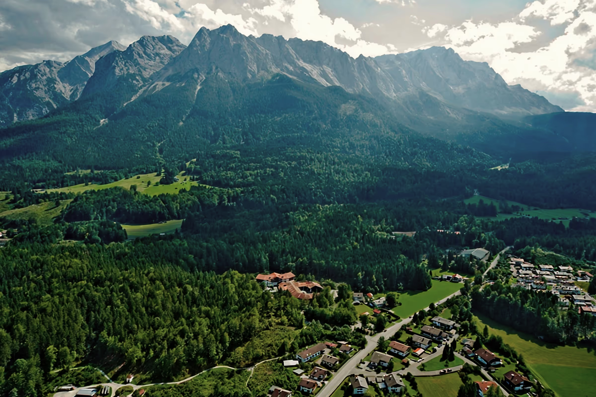
A perfect day in Grainau: Around the Wank

The circular hike around the Wank without climbing the summit is a moderate and yet less frequented tour option in the Ester Mountains. The route is feasible in almost any weather. The starting point and even the course can be selected flexibly. There are also several huts along the route where you can stop off, and if you like, you are welcome to take the Wank summit with or without cable car assistance.
Tour profile
Difficulty level: easy to medium
Route length: approx. 17.5 km (total)
ascents: approx. 700 hm
descents: approx. 700 hm
Around the Wank: That's how it works
11:00 a.m.: This time we are going around the wall counterclockwise. We start in Partenkirchen and walk towards Hasentalstraße until we reach the lower path to the Pfeiffer-Alm. The trail is flat and also suitable for less sporty hikers. After an easy climb on the outskirts of the village, the route runs through the forest and past meadows with a panoramic view of the Wetterstein massif on the right.
11:50 a.m.: It takes us less than an hour to reach the Pfeiffer-Alm — at just the right time for a lunch break. The family-run hut is located at an altitude of 1,000 m with a wonderful view of the Alpspitze, the Waxsteine and the Zugspitze. When the weather is nice, the sun terrace is an absolute highlight. Here we fortify ourselves with soup and homemade cake.
1:00 p.m.: From here, continue on an asphalted country road towards Gschwandtnerbauer. After a short time, we reach the car park, where you can alternatively start the Wankrunde. It's only uphill from here: the entire altitude difference on our route is between the car park and the Wanksattel. Alternatively, the route between Partenkirchen and Gschwandtnerbauer can be reached via the Tannenhütte do.

It takes just under 20 minutes from the parking lot to Berggasthof Gschwandtnerbauer. Although we always like to stop by here (the curd strudel is always worth it!) , it continues right away today. On the left above the hut, you will find the further route, which leads steeply through the mowing meadow and disappears into the mountain forest after a few meters. At the fork in the signs: turn left to the Tannenhütte (“Steinbichl” hiking route) and straight on to Esterbergalm and Wank summit. The climb is steep but pleasant: the trail snakes through the cold water ditch, a picturesque water channel, and the forest becomes ever brighter. Rocky passages alternate with mossy forest areas covered with mountain pine trees.

2:00 p.m.: There are only about 600 meters in altitude between our starting point in the valley and the Wanksattel, which we will soon reach at an altitude of around 1300 m. Here is another signpost: If you want more altitude difference, you can take the route to the left to Rosswank. However, we are continuing our relaxed hike to Esterbergalm. After the saddle, it goes slightly downhill. The wide footpath runs parallel to the rocky stream bed. Small waterfalls rustle on the rocky steps and accompany us down to the high valley, where we can already see the Esterbergalm from afar. The total walking time from Gschwandtnerbauer to Esterbergalm is 1 to max. 1.5 hours.

3:00 p.m.: Once at the Esterbergalm (1,262 m), we treat ourselves to a drinking break. It is a bit unfortunate that we are not hungry; the alpine hut is known for its excellent cuisine. The rustic alpine pasture, which was founded in the 16th century at the latest, is primarily used for animal husbandry — just like the other, non-public alpine huts here on Esterberg. Mighty mountain peaks protect the valley from wind, crystal-clear streams jump off the valley walls and the grasses thrive on the alpine soil. Hundreds of calves and sheep graze on the lush meadows here in summer. As we leave the alpine pasture, curious horses and their foals accompany us, who can be petted with a little care.

4:00 p.m.: Now we continue on the wide forest road towards the valley. After about 10 minutes, we reach the signpost: here at the edge of the forest, the Hüttlsteig starts to the left - a shortcut to the Wankbahn middle station, which you can really use at a starting point in Partenkirchen or in Schlattan. So you can descend from the middle station to the Tannenhütte and on to Partenkirchen. But it goes straight ahead for us, as we have decided to descend to Farchant and the picturesque Philosophenweg. There are many routes on the Wank, all of which offer their advantages. After the steep asphalted S-bend, the Farchanter Steig is not far away anymore. At the signpost, we turn right and prefer to use the natural, slightly less frequented hiking trail than the wide road that leads directly to Partenkirchen via the Daxkapelle.

5:15 p.m.: After 4-5 turns, we reach the “Scharfes Eck” service area with its funny “Farchanter Radhaus”. Here is a wooden table with a bench for hikers. After a few meters in altitude, we hear the sound of water from the small waterfall. The route ends in Farchant in wide curves through the forest.

5:45 p.m.: Right where our trail flows into Esterbergstraße, it is possible to turn left to the panoramic Philosophenweg to turn. The fork is marked with a signpost. After an easy climb, we are above the Farchanter Warmfreibad and follow the trail until we reach Partenkirchen. After the church of St. Anton, we leave the mountain trail and get back to the town center of Partenkirchen to our car. For relaxed hikers, the walking time from Farchant to Partenkirchen is just over an hour.
Possible route options
Depending on how fit you are and in which direction you want to make the round trip, the following sections of the route are possible, which can be flexibly combined with each other on the 17 km long hiking route:
- Bergstraße from Wankbahn car park in Partenkirchen to Esterbergalm
- Farchanter Steig From Esterbergstraße in Farchant via “Scharfes Eck”, ends at the top of the mountain road to Esterbergalm
- One of the many ascents from Partenkirchen to Tannenhütte
- Philosophenweg between Farchant and Partenkirchen
- part of Top hiking trails about the pilgrimage church of St. Anton
- Hiking trail via “Steinbichl” between the Tannenhütte and Berggasthof Gschwandtnerbauer
- Hiking trail through the cold water trench between the Wanksattel and Berggasthof Gschwandtnerbauer
- Unterer Weg from Partenkirchen via the Pfeiffer-Alm to the Gschwandtnerbauer
- Hiking trail from the Wankbahn middle station to the Daxkapelle
- “Hüttlsteig” high-altitude trail from the Wankbahn middle station to Esterbergalm
Starting point
You can also flexibly select the starting point:
- From Partenkirchen: Wankbahn valley station hiking car park (chargeable) or another parking lot in Partenkirchen (e.g. at Gipsbruch)
- From Farchant: Farchant outdoor swimming pool car park in Esterbergstraße (chargeable)
- From Schlattan: Berggasthof Gschwandtnerbauer car park (limited parking capacity)
Tips & info:
- Gasthof Pfeiffer-Alm (closed on Tuesdays and Wednesdays)
- Berggasthof Gschwandtnerbauer (closed Monday and Friday)
- Berggasthof Esterbergalm (Summer: Wednesday day off, winter: open Thursday - Sunday, Christmas & Easter holidays open daily)
- Tannenhütte (closed on Mondays and Tuesdays)
- Arriving by bus: From the Hotel am Badersee, take the Eibsee bus to the last stop “Sebastianskirche” in Partenkirchen. You can start the hike directly from here.

Heartily Wellcome
at Lake Badersee