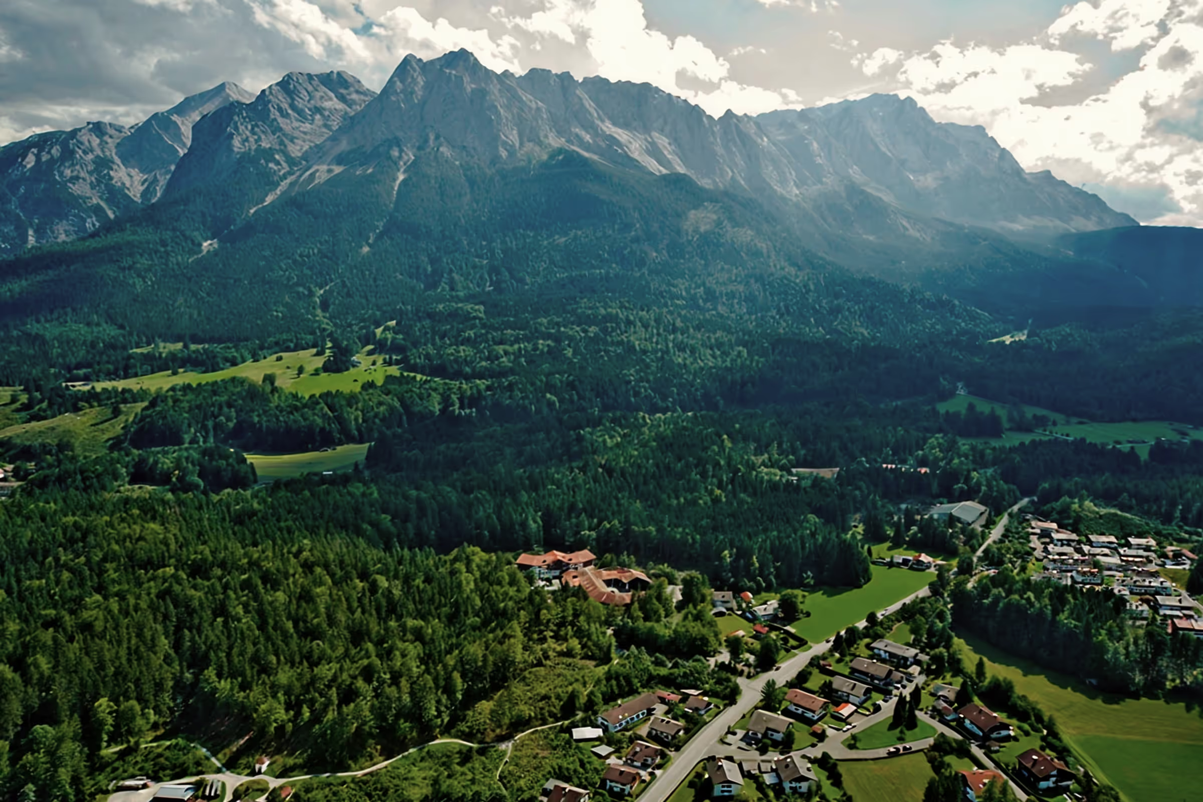
A perfect day in Grainau: circular hike across the Kuhfluchtklamm, Hohen Fricken and Oberauer Steig

The trail through the cow escape to Hohe Fricken is one of my favorite hiking trails in the Loisach Valley. A warm and sunny day at the end of May is a perfect opportunity to explore the mountains. Whether the ridge is already free of snow and the trails at the top can be walked on again? Today I can check whether the summit hiking season can start again.
Tour profile
Difficulty level: difficult
Route length: approx. 13 km (total)
ascents: approx. 1300 m
descents: approx. 1300 m
The times in the text can be used as a reference for experienced mountaineers. Less experienced mountaineers should plan much more time. Depending on the weather, the tour is available from the end of May to October and weather permitting. The trail across the Kuhfluchtklamm gorge is not suitable for the descent; when wet, it is no longer accessible even upwards. In May, you also have to watch out for possible avalanches in the upper area. Therefore, please note our Safety tips for mountaineers.
9:20 a.m.: I drive to Farchant, where I follow the signs to the Kuhfluchtwasserfälle. I park here. We continue on foot, first through the blooming forest on the shore. I will soon reach the first bridge, from here begins the usual hiking trail through the gorge. The trail passes all waterfalls, and from time to time it is possible to get closer to the water and freshen up a bit if needed.
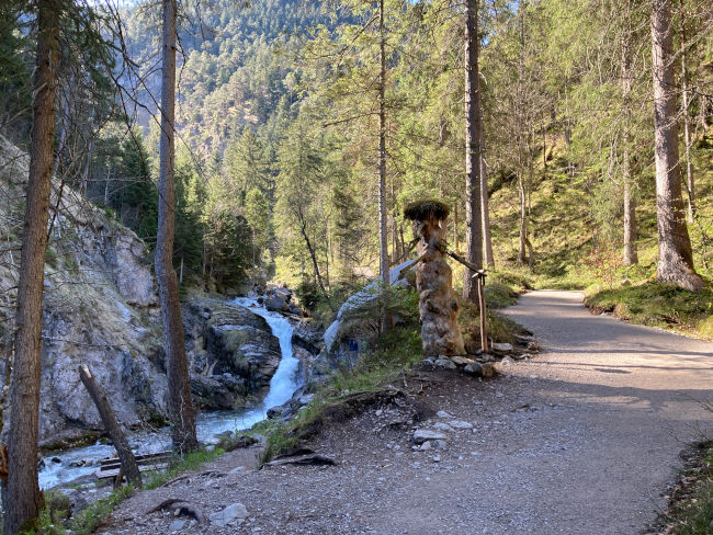
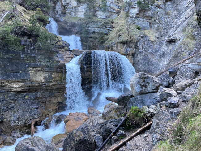
9:40 a.m.: Now I also reach the upper bridge, from here you have a wonderful view of the large waterfall. I briefly take the narrow path down that takes me straight to the waterfall to admire the falling water up close. I then cross the bridge and follow the steep rope-protected path up, which takes me to the upper level of the waterfall in a few minutes. The huge water masses are particularly impressive in spring.
9:50 a.m.: After enjoying the waterfall extensively, I continue upwards towards Weilheimer Hütte. The route is easy to find and well signposted. The steep trail runs in narrow curves through the bright mountain forest consisting of pine trees. The Farchanter Waterfall rushes right next to it. It comes from a karst spring, which is part of an incredible cave system in the Ester Mountains, and jumps out of the Frickenhöhle above Farchant towards the surface. The cave is located in rough terrain and can therefore only be reached by climbing, it is over 3 km long and leads through a lake and several siphons.

10:10 o'clock: After about 20 minutes, I reach the first viewpoint with a wonderful view of the Zugspitze massif. Someone here is even lying peacefully in the sun and reading a book completely relaxed, even if it goes steeply down right next to it. Although space is very tight, I sit down briefly to enjoy the view as well. Then I continue again until I reach a small clearing where there is an emergency shelter for mountaineers. The steep stone gutter on Fricken, through which the waterfall rushes, goes almost to the summit and the route has so far followed the course of the gully. From here, the path changes direction a bit and the perspective changes, so that I have Oberau, Eschenlohe and, surprisingly, Ettal in mind. I'm taking a short drinking break at the emergency shelter.
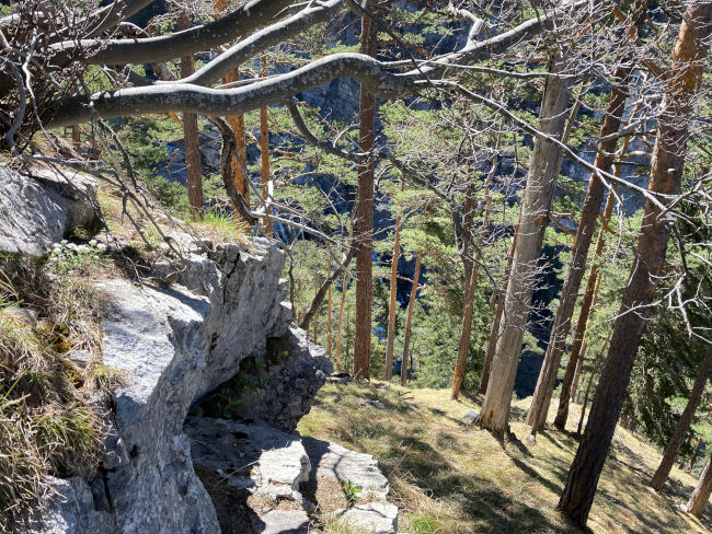
10:30 a.m.: Shortly after, the trail gets steeper, with slight rocky climbing sections, but extremely picturesque. Alpine flowers adorn the otherwise barren rocks. You need absolute sure-footedness here. There are a relatively large number of hikers on the route next to me, and I am even met by an elderly couple at this hour. You have to walk carefully and wait from time to time until everyone gets through the crash area safely. The trail comes to a narrow plateau covered with mountain pines and small spruce trees and I'm just happy that the steep part is probably over now.
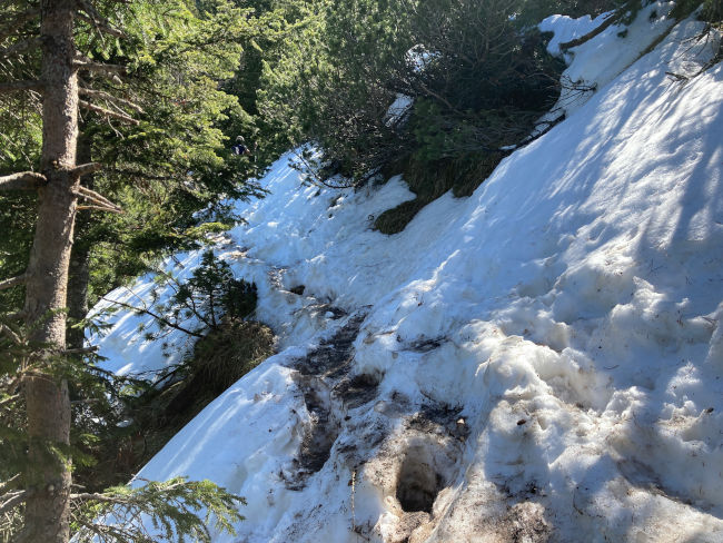
11:15 a.m.: I was wrong. The road is getting worse. First, the trail continues steeply uphill, then a short time later it goes into the thick forest, where the snow has only recently melted. Due to the high number of hikers, the entire route has become extremely muddy and dangerously slippery. This is now also followed by deep snow. The first few meters are a mixture of snow and mud, then the snowpack closes and you sink knee-deep into the snow with almost every step. Good thing I have my leggings with me.
11:35 a.m.: After the first difficult meters of altitude in snow, I hope that it will perhaps be snow-free at the top, where the solar radiation is generally stronger. After the next bend, however, it becomes clear that the snow hasn't melted away yet. Because the snowfield that I'm seeing right now in front of my eyes should actually be a mountain pine forest! This means that the snow here is still at least 2 meters deep. At this altitude, winter will last even longer. In front of me, I notice a young lady taking a break in the snow. Does she need help? There are only 200 meters left until the summit, so I try to encourage them accordingly. No, she doesn't need any help, but it's the most difficult altitude difference and the view is so beautiful...
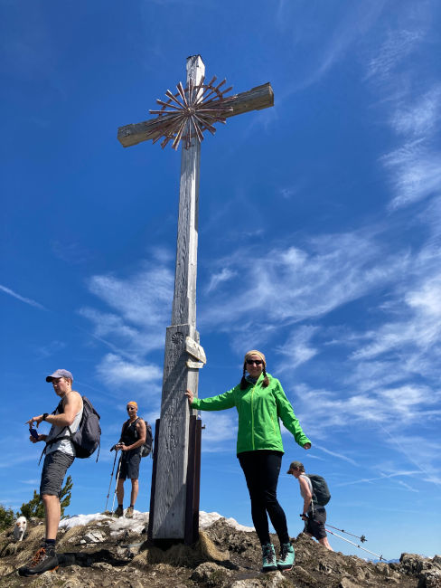
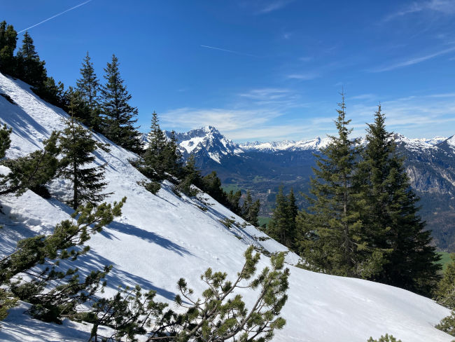
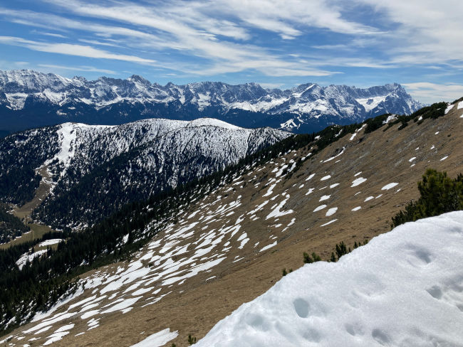
12:15 p.m.: My snow hike has finally come to an end and I reach the ridge at 1,940 m. Shortly before the Fricken summit, our route leads to one of the high-altitude trails that connect the Hohe Kiste with the Esterbergalm. The summit cross on Hohen Fricken is only a few meters away from here. The summit is very crowded today when the weather is nice: two dozen hikers are taking a break here in the warm sun. I'll join the others and unpack my snack. The sun has a relaxing effect until I notice that my skin starts to burn after a few minutes from the intense sun exposure. It is time to head back to the valley.
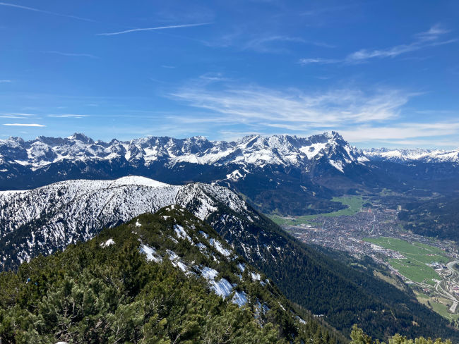
12:40 p.m.: Although the Ester Mountains from the Loisach Valley look quite steep, there are a few routes here that lead up through the wild slopes. Today I choose the Oberauer Steig to complete my circular hike. The trail starts below the bishop and has a branch to Farchant at the bottom, which leads me directly back to my parking lot. I pack up my backpack again and set off along the ridge towards Weilheimer Hütte through deep snow. In contrast to the ascent, the descent through the masses of snow is a lot of fun. Here, the white, untouched snow was shaped by the wind into unusual shapes that artfully weave around the mountain pine trees. The risk of avalanches is relatively low here on the ridge, and hopefully it will remain the same on the Oberauer Steig.
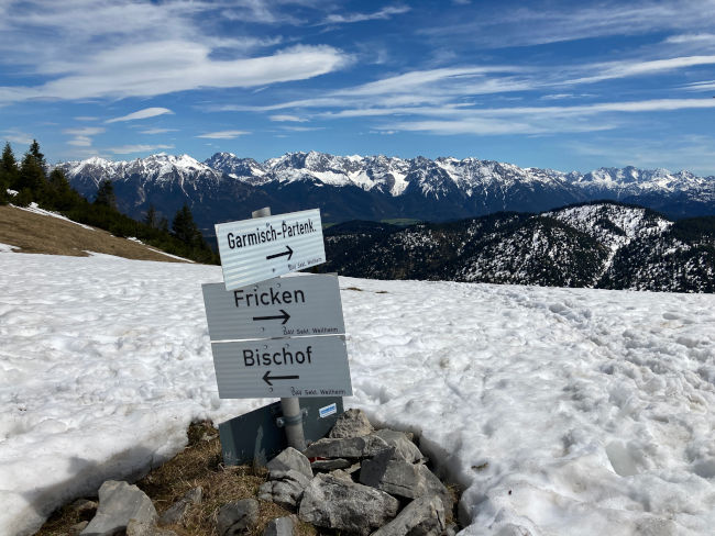
1:15 p.m.: After approx. 200 m, I am on the saddle between Fricken and Bischof. Here, the route is again marked with a sign and continues towards Weilheimer Hütte. After a few minutes, the turnoff to Oberauer Steig below the bishop comes. Here it goes steeply down until I reach the wide meadow where the cows graze in summer. The meadow is currently a huge snowfield, which is fortunately relatively flat and therefore harmless from an avalanche point of view. After the snowfield, the hiking trail goes through the pine trees into Frickenkar and comes out below Kleiner Fricken at a distinctive cattle watering hole. From here, there are exactly 1,000 meters of altitude difference down to the valley. The rest of the trail disappears into the snow and the slope is so steep that I have no choice but to simply slide down on my back. It saves me some time and is certainly fun, apart from the fact that my clothes are now soaking wet. I need to hurry up a bit to stay warm.
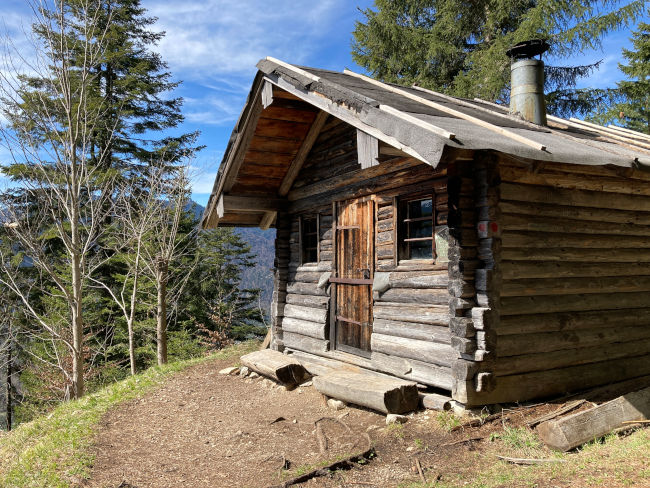
2:15 p.m.: A short time later, the forest line comes. In the forest, the snow is getting smaller and then it completely disappears. It's also getting warmer right away. Then I reach the small private Schafalm Hut with its cozy bench at 1,050 m. It is worth taking a drinking break here again with a view of the valley.
2:40 p.m.: It takes about 1 hour from the hut to the valley. The trail goes through bright mixed forest, steep scabbed passages alternate with easier routes. However, the Oberauer Steig is not as steep as the route across the Kuhfluchtklamm gorge and is therefore more suitable for the descent. At around 3:30pm before Oberau, I reach a fork at a small waterfall: turn right straight to Oberau, the trail continues straight ahead towards Farchant. Since I parked in Farchant, it's just turning off for me. Shortly after, I'll get off a small moor on the hiking route “Farchant on Origins”. From here, it is only a few kilometers to Farchant. My hike is over shortly before 4 pm and I'm off to the Farchanter ice cream parlour to celebrate the first hike of the summer season with delicious ice cream.
Tips & info:
- Getting there: If you want to travel by public transport, take the bus from the Hotel am Badersee or the Zugspitzbahn to the train station in Garmisch and from there take the regional train to Farchant. The Kuhfluchtklamm gorge is only a 10-minute walk away from the train station. Sports enthusiasts can also travel from the Hotel am Badersee by mountain bike or e-bike, it takes approx. 50 minutes. Parking spaces are available for cars at the Farchanter Sports Center and at the Kuhflucht (for a fee).
- rations: There are no mountain huts on the described route, so bring enough drinks and food. In an emergency, the hiker is faced with Weilheimer Hütte as well as the Esterbergalm available (check opening times).
- Kuhfluchtwasserfälle: The trail to the cow escape waterfalls is also feasible for families or leisure hikers. You should then descend the same way again.
- equipment: The tour is for experienced mountaineers! Be aware of the right equipment and weather conditions. Read our blog on top of that.

Heartily Wellcome
at Lake Badersee