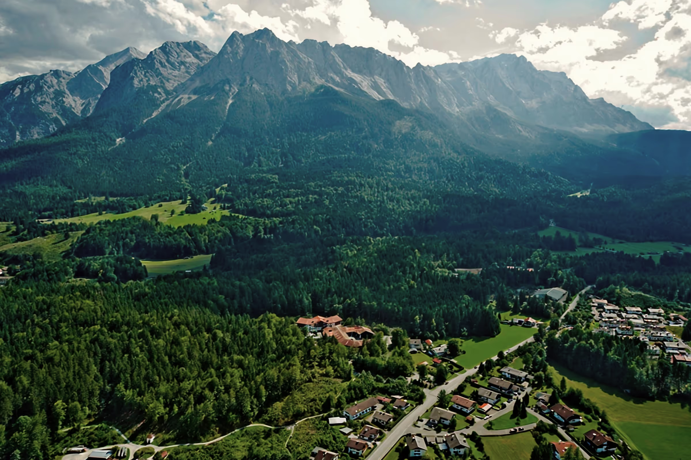
A perfect day in Grainau: hiking to Esterbergalm
The Esterbergalm is located at an altitude of 1,262 m on the high valley floor in the Ester Mountains between the Wank, the Hoher Fricken and the Krottenkopf. Known and popular for its music festivals and as an excursion destination for families, the hut is an important stop for mountain bikers as well as for hikers on longer alpine tours through the Ester Mountains.
Tour profile
Difficulty level: medium
Route length: approx. 10 km (total)
ascents: 600 hm
descents: 600 hm
The hut can be reached via several routes. Today we're taking the shortest route from Farchant.
10:00 o'clock: The starting point is on Esterbergstraße. Just before the ski lift at Ried, take the signposted forest road on the left and a short time later follow the footpath to the left towards Esterbergalm. The trail takes small bends through the bright beech forest. We pass a small waterfall and take a break at the next bend as usual at the so-called “Farchanter Radhaus”. After that, it takes about 30 minutes and 4-5 turns to reach the forest road that leads to Esterbergalm.

11:00 o'clock: Since the forest road is quite steep at this point, we take a short breather on a bench that stands invitingly on a slope and offers a wonderful view of Farchant and Burgrain. The forest road was part of a ski slope until 2004, however, after the closure of skiing operations on Wank, it slowly becomes overgrown with young trees. After the steepest stretch, the road returns to the plain. Before we reach the hut, we pass two important junctions: on the left across the pasture, we continue to Hoher Fricken and shortly after, there is the sign “Wank über Frauenmahd” on the right side (the path that we already use in our blog Have reported).

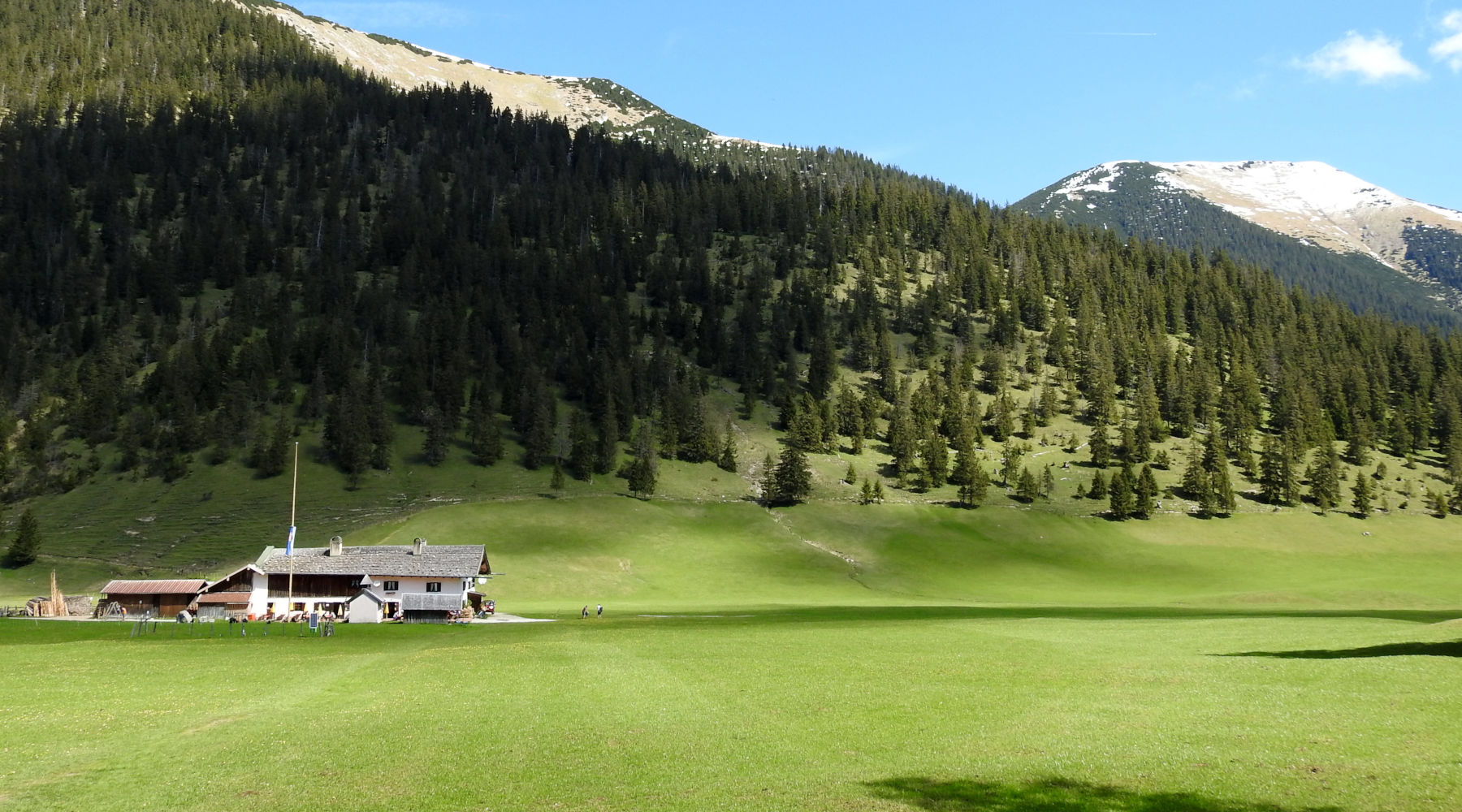
12:00 o'clock: The Esterbergalm is easy to see even from afar. The rustic listed hut has belonged to the Garmisch-Partenkirchen market since 1545. In 1803, the Josef Chapel was built in the courtyard, which is also a listed building. Together with Farchanter Alm, Esterbergalm operates a large pasture area in the heart of the Ester Mountains. Although the alpine hosts always have their hands full, hikers and mountain bikers always feel welcome here and enjoy hearty alpine cuisine with a view of the summit.

From the Esterbergalm, you can reach numerous alpine tours, huts and connections in the Ester Mountains. The nearby Weilheimer Hütte (1,955 m) is the highest mountain hut and the Krottenkopf, at 2,086 meters, is the highest mountain in the Bavarian Prealps.
Cabins nearby:
- Berggaststätte Gschwandtnerbauer (1,020 m)
- Tannenhütte (1,000 m)
- Finzalm (1,040 m)
- Weilheimer Hütte (1,955 m)
To the hut from below:
- Wankbahn valley station (730 m) - to the middle station with the gondola (1,175 m) - via Daxkapelle or Hüttlsteig - Esterbergalm (easy, ascent approx. 100 hm, descent approx. 500 hm)
- Wankbahn valley station (730 m) - to the mountain station with the gondola (1,780 m) - descent via Frauenmahd - Esterbergalm (1,262 m) - Daxkapelle - Wankbahn valley station (easy, descent approx. 1050 m)
- Partenkirchen (708 m) - Tannenhütte (1,000 m, formerly Gamshütte) - Gschwandtnerbauer (1020) - Esterbergalm (easy to medium, ascent approx. 550 m, the route is used more as a descent from Esterbergalm to Partenkirchen)
- Farchant (672 m) - Scharfer Eck - Esterbergalm (easy to medium, ascent approx. 600 m)
- Partenkirchen (708 m) - climbing forest - Daxkapelle - Esterbergalm (easy to medium, ascent approx. 550 m. The route is suitable as a bike path but is sometimes very steep - up to 26%.)
- Wank circular hiking tour: Wankbahn valley station (730 m) - Wank middle station with the gondola (1,175 m) - Hüttlsteig or via the Daxkapelle - Esterbergalm (1,262 m) - Gschwandntnerbauer via Kaltwassergraben (1,020 m) - Tannenhütte (1,000 m) - St.Anton in Partenkirchen (740 m) - Wank valley station (medium, ascent 600 hm, descent 1,020 hm)
- Farchant (670 m) - Kuhfluchtwasserfälle (850 m) - Hoher Fricken (1,940 m) - Esterbergalm (difficult, ascent 1,270 m)
- Oberauer Steig (start in the Loisach Valley between Farchant and Oberau at 650 m) - Hoher Fricken (1,940 m) - Descent to Esterbergalm (difficult, ascent 1,270 m, descent approx. 650 m)
- 2-day tour: Eschenlohe (640 m) - Hohe Kiste (1,922 m) - Overnight at the Weilheimer Hütte (1,946 m) - Descent to Esterbergalm (1,262 m) - Wank (1,780 m) - Garmisch-Partenkirchen (1,700 m) (difficult, ascent approx. 2,000 hm, descent approx. 1,800 hm)
- MTB bike tour: Krün (875 m) - Finzalm (1,040 m) - Farchanter Alm (1.270) - Esterbergalm (1,262 m) - Daxkapelle - Wankbahn valley station (730 m) (difficult, ascent 1089 m, length 32.6 km)
From the hut to the top:
- Esterbergalm (1,262 m) - via Frauenmahd or Rosskopf - Wank summit (1,788 m) (easy to medium, ascent approx. 500 m)
- Esterbergalm (1,262 m) - Hoher Fricken (1,940 m), Bischof (2,033 m), Kareck (2,046 m) or Oberer Risskopf (2,049 m) (medium to difficult, ascent approx. 1,100 m)
- Esterbergalm (1,262 m) - Farchanter Alm (1,270 m) - Krottenkopf (2,086 m) - Weilheimer Hütte (medium to difficult, ascent approx. 800 m)
- Esterbergalm (1,262 m) - Weilheimer Hütte (1,946 m) - Hohe Kiste (1,922 m) - Eschenlohe (640 m) (difficult, ascent approx. 800 m, descent approx. 1400 hm)
Tips & info:
- Berggasthof Esterbergalm (Summer: Wednesday day off, winter: open Thursday - Sunday, Christmas & Easter holidays open daily)
- Opening hours: Observe rest periods in the huts. The Weilheimer Hütte is very popular, please book sleeping places in advance.
- Descensions towards Farchant/ Oberau/ Eschenlohe: Since the western face of the Ester Mountains is very steep, it is not recommended to use the trails between Eschenlohe and Farchant to descend from the Weilheimer Hütte when wet. Then use the forest roads to Eschenlohe or from Esterbergalm to Partenkirchen.
- MTB riders watch out: The descent from Esterbergalm towards Partenkirchen is very steep (up to 26%). The branching path to Farchant is not suitable for mountain bikes, please use the forest road.
Heartily Wellcome
at Lake Badersee