Top hiking trail stage 7: From Schachenhaus to Kreuzeck

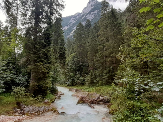
The seventh stage of the peak hiking trail takes long-distance hikers from Schachen down to Reintal and then back up to Kreuzeck. An extremely scenic hike, which, however, also requires a head for heights and sure-footedness. You shouldn't be distracted by the beautiful views as you descend into the valley today. When the weather is clear, there are fantastic views; even from Schachen, you can see the final destination of today's stage in the distance and also make the way down into the valley. The crystal-clear Partnach River and the sound of rushing waterfalls accompany hikers along the way.
Tour profile
Difficulty level: difficult
Route length: approx. 24 km
ascents: 750 hm
descents: 800 hm

Map © www.ich-geh-wandern.de
Top hiking trail — experience the natural landscape of the Zugspitze region over 200 km
Not too long ago, the Spitzenwanderweg was ceremonially opened. The long-distance hiking trail covers 200 km and 12 stages through the picturesquely diverse landscape of the Zugspitze region. More than 6,800 meters of altitude difference are also covered, so the top hiking trail is quite a sporting endeavor. But it's worth it. Because the trail leads through a diverse landscape and also passes through numerous cultural monuments. The start and end point is the picturesque town of Murnau. Two overnight stays in huts are included on the long-distance hiking trail, once in the Soiern House and once in the Schachenhaus. On the 200 km, hikers pass fantastic views, flower-rich mountain and moor meadows, deep blue mountain lakes, bubbling springs and rivers, the spectacular Partnach and Höllental gorge, foothills of the Alps with far-reaching views, as well as cultural monuments such as the royal castles of Schachen and Linderhof Castle, as well as typical Bavarian villages such as Murnau, Krün, Mittenwald, Grainau or Oberammergau. There is therefore much to experience and discover on the 200 km long trail.
And we too are keen on the long-distance hiking trail and are treading this stage by stage, because the trail will also be a special experience for us locals. I will walk the path partly alone, but also with my colleague. Join us on the hiking trail.
The top hiking trail: All stages at a glance
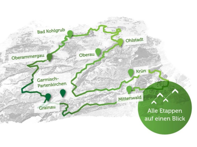
Picture © spitzenwanderweg.de
To stage 6: From Mittenwald to Schachen
Stage 7: From Schachenhaus to Kreuzeck
“Can't you fly like an eagle
Just climb uphill step by step;
Who won the summit with difficulty
The world is also at your feet. ”
Victor Blüthgen, German poet and writer, 1844 — 1920
After a good night's sleep and cheer up early, I'll test my muscles first. Will I have sore muscles after yesterday's heavy stage, will my calves ache? It all looks good. My muscles seem to have withstood the hike really well. I didn't expect that now, but all the better, because today we have another intensive hiking day ahead of us. While Polly is still under the covers, I sneak out of the room because I want to see if there's a nice sunrise over the mountains today. I can also get an idea of the weather right away. It hasn't rained for once and the cloud cover from yesterday has mostly warped. It actually seems as though the weather is showing its best side today. The sunrise may not be as great as I had hoped, but I'm already satisfied with the views.

My hiking boots, socks and hiking pants are wonderfully dried in the drying room and back in the room I get my toiletry bag to get ready for the day. Without further ado, I blow dry my hair in the drying room with a large air blower. It works wonderfully, you just stop in front of it. Polly is ready too and we are looking forward to a hearty breakfast. Since we don't have our own hiking sandwiches with us today and the first stop will only be possible at the Bockhütte, a hearty breakfast is important to strengthen our batteries. Before we start, let's take a look at the weather forecast again. Once again, we have a different weather forecast. My weather is getting sunnier and sunnier over the course of the afternoon (wetter.de), Polly is expecting rain (weather.com). I hope I'm right this time.
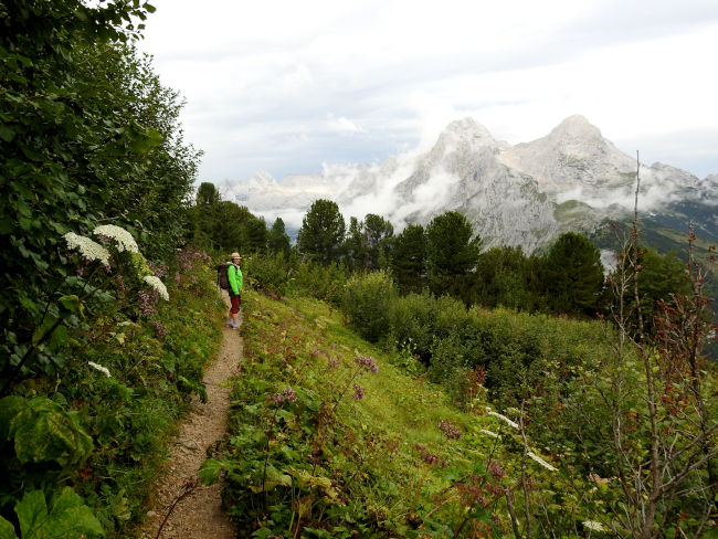
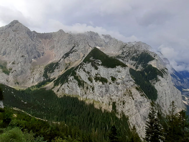
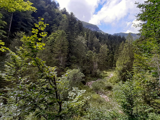
At least this morning, the view is excellent, so that we can already see the Kreuzeckhaus on the opposite side of the mountain from Schachen. It is easy to see how the top hiking trail will take us down to Reintal, but how we will be led up to Kreuzeck is still questionable to us. For now, it's downhill, meter by meter. The top hiking trail is thus the first stretch along the Via Alpina and an information sign from the German Alpine Club once again indicates that alpine experience, sure-footedness and a head for heights are required.

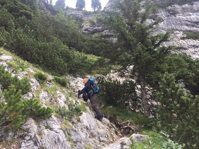
Just behind a viewpoint, you can see what awaits us on the descent. Polly has walked this path before, the descent is new territory for me. The trail is rocky and narrow and requires a high level of concentration. I can't let my gaze wander too much over the beautiful landscape. Some steps lead steeply down, sometimes there are a few climbing passages and partly a safety rope is attached to the rock to provide support. In some places, however, I am missing the safety rope, in others where there is one, I don't think it would be necessary.
Where you usually go downhill quickly, you prefer to hike this section of the trail with care and caution. The hiking poles help with sure-footedness and so it continues downhill turn by bend into the Upper Reintal Valley. The view is incredibly beautiful, but I'd rather stop for a photo than take a step. Unfortunately, my camera battery has given up the ghost and the spare battery, which I actually charged two days earlier, is also apparently empty. On this tour of all places, which you don't even run every week. At least the mobile phone is charged and so I can only take pictures of the tour.
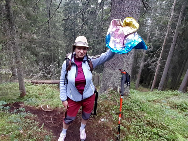
We have mastered the hardest part of the descent and are happy that this happened in dry conditions, even though the trail was still partly wet from the previous day. We reach the Upper Reintal Valley, where we say goodbye to the distances and views, because the trees obscure every view. Unfortunately, people manage to leave their trash even in the remotest corners, this time we pull the rest of a balloon out of a tree and store it in a backpack to dispose of it properly later. As nice as it may be to let balloons fly, you shouldn't do that anymore because of nature.
Having left the first long descent behind us, a flock of sheep greets us in the Upper Reintal Valley. From here, it continues into the Reintal valley, further and further downhill. You slowly become aware of how high you were on the mountain and how low you now have to descend again to reach the valley. I'm happy that I don't have to walk this way up to Schachen, even though Polly tells me that it can be done. I think my muscles would yell at me and go on strike. So I admire the individual men who have just come to meet us and do so with ease, as if it were a walk on a flat plane.
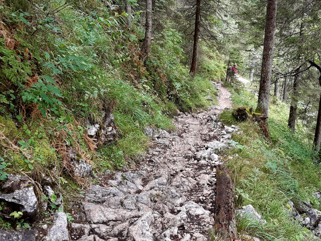
The sound of waterfalls now accompanies us down into the Reintal Valley. Some of us have a view of the waterfalls, then the path moves away from the water and the noise remains behind. We continue downhill on narrow, rocky paths.
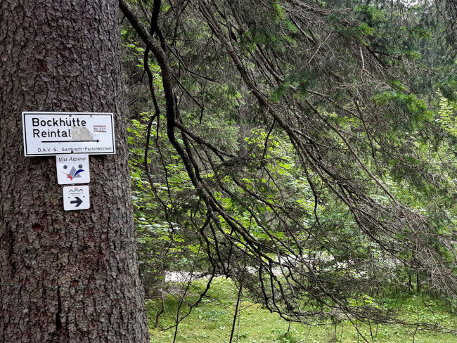
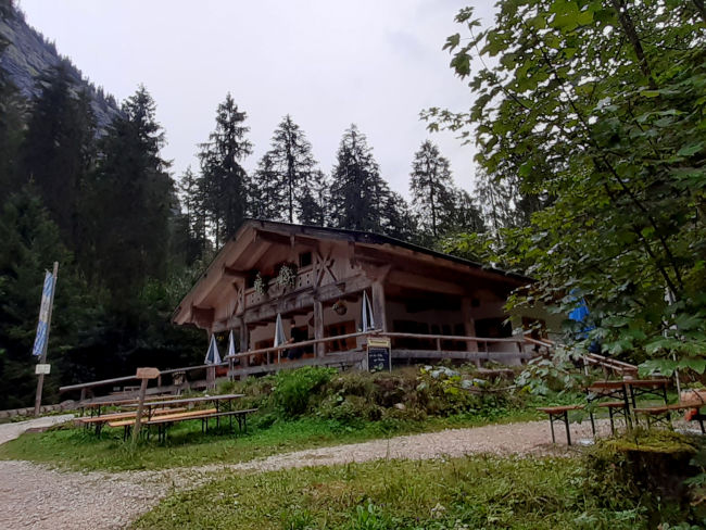
After about 2:30 hours of descent, we reach the valley and branch off to the Bockhütte, where we want to take a first break. Despite the good breakfast, we have an appetite, we have certainly burned enough calories on the descent and a refreshment for the subsequent climb won't hurt.
The Bockhütte is picturesquely situated in the Reintal valley on the banks of the Partnach. It is the destination of many hikers, but it is still quite early in the morning. The menu is also quite manageable, but today it offers pea soup with sausage, which sounds pretty good to both of us. On the one hand warm and on the other hand filling enough to get to Kreuzeck. Unfortunately, it turns out that the chef is probably in love, because the pea soup is pretty salted, so we're not really getting the culinary treat we were hoping for so much. A longer break is also not possible, because from the terrace of the Bockhütte we see rain clouds moving in and it actually looks as if Polly's weather forecast was right once again. Although my weather report says it's still dry and increasingly sunny, it's still going to rain for Polly.
The top hiking trail now runs straight along the Partnach, a recovery phase for our legs, after the long descent and the upcoming ascent. I thank God almost every time I get to run a flat section on a mountain tour. That is a real treat for the legs. We are now taking a quick step to the tabernacle. However, I would not have thought that the journey would be quite long until then. I had expected the tabernacle almost close to the Bockhütte.
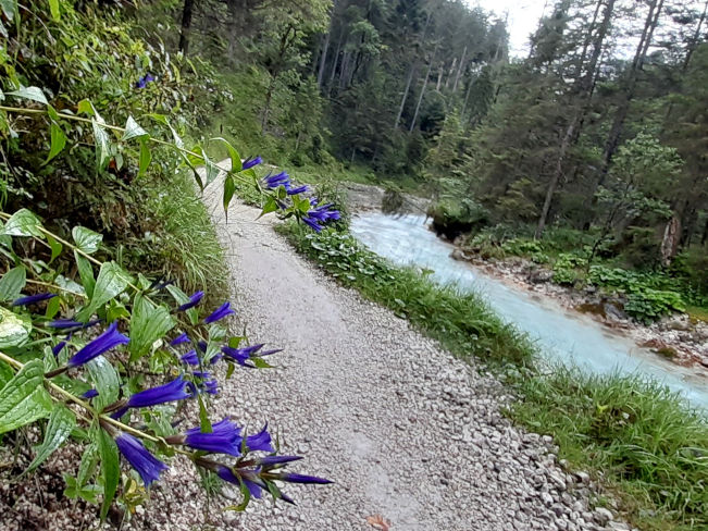
The way there is also picturesquely beautiful at first, parallel to the shimmering ice blue Partnach to the point where the river deepens into the gorge and from there continues to flow to the famous Partnach Gorge.

The road is getting wider and wider to become a roadway for cars with special permits. It then branches off and climbs slightly uphill to the tabernacle. This route is very popular with mountain bikers who cannot drive through the Partnach Gorge but come across the wide road to Reintal and like to drive up to the Bockhütte. Accordingly, in addition to hikers, we are also met by many mountain bikers.
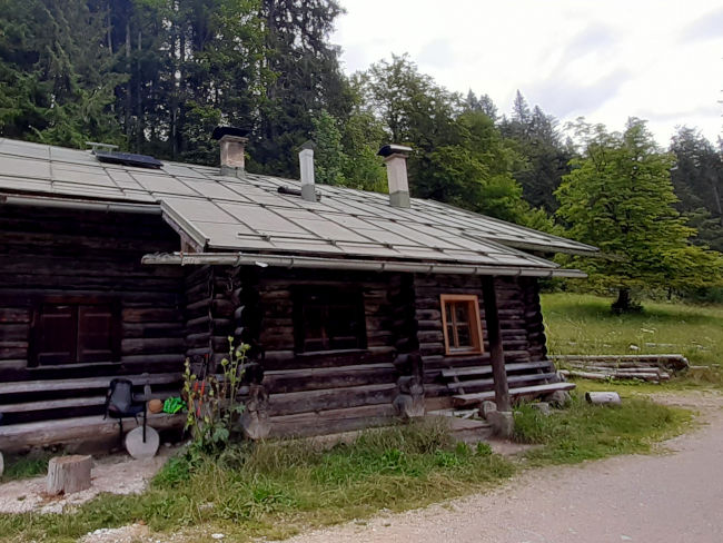
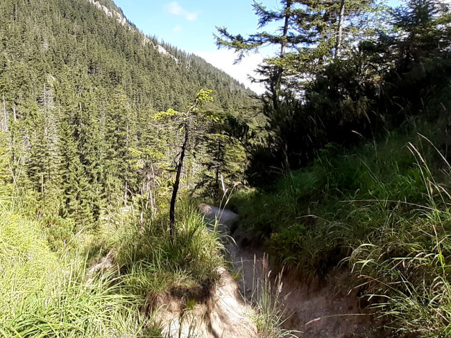
We have now also reached the tabernacle and this offers us a second break before the steep climb up to Kreuzeck begins. The weather seems to be improving again, fortunately there is no sign of rain, the clouds have mostly disappeared. While we are sitting here comfortably, we even see a marten frolicking on a nearby pile of wood. And right now I don't have a camera anymore. How annoying. After a long rest, it's time for us to move on. At first, we fear that the hiking trail will lead up to Kreuzeck, which is specifically intended for mountain rescue vehicles, but after a turning point, we will enter the forest on a narrow path.
We follow the path, which is becoming increasingly picturesque and initially leads relatively gently up the mountain. The weather is also improving more and more, blue skies are slowly showing above us and the sun's rays are increasingly penetrating through the cloud cover. My weather forecast was right today.

We are back on secluded paths, far away from the highly frequented hiking trails. We're trying to guess exactly where we'll get along later on, we already have a premonition, but we're not quite sure yet. Halfway up, we treat ourselves to another break for drinking and taking a breather and simply enjoy the warming sun and the views that await us along the way.

The higher we climb, the more beautiful our views back to Schachen become. Our whereabouts yesterday seem far away to us. On the other hand, we can't figure out our destination yet and so it's time to continue climbing the mountain, turn by bend. Further up, we now also reach some climbing sections. Some trees fell over during the storm and are blocking the path. Sometimes we can climb over the trunks and force our way through the branches, sometimes we have to get off the path and a bit steeply up the slope to get back on the path.
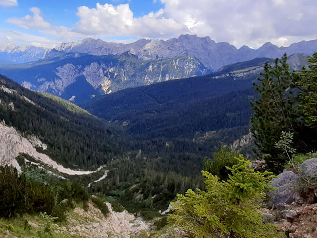
Polly is already three bends above me, I would really like my legs to strike. But the end can't be far off and then I hear Polly shouting the magic words to me: “I'm on top! ”. Two more bends and I've done it too and we're right at the junction of the Kreuzeck-Alpspitze hiking trail, which we've already guessed. We're over the moon now. A little further on, there is a view from which we can retrace our current hiking trail. Down into the valley, turn right and then up to the Königshaus am Schachen, which is clearly visible on the other side on the mountain summit.
What a terrific hike we have behind us. Insane! The last stretch to Kreuzeckbahn is now really just a walk away. We want to finish the stage in a good restaurant in the valley. As wonderfully varied and scenically fantastic as this two-day hiking tour was, it was not a culinary highlight. And after all the effort and effort that has really paid off, a good dinner is now an absolute must. So we buy our ticket for the mountain railway and off we go, this time comfortably down into the valley.

We have completed two of the hardest stages of the top hiking trail with flying colors and we are already looking forward to the next stages. But today I'm sure that I'll feel my muscles tomorrow.
Tips & info:
- Route length: 11.5 km, performance kilometers: 24 km
- Walking time without a break: approx. 4 hours 42 minutes (we would set aside more time for this trail, approx. 5 hours 30 minutes to approx. 6 hours)
- Altitude approx. 726 m high, 549 m down, highest point 1,878 m
- Difficult hike, mostly mountainous terrain, mostly on narrow, small trails, good hiking boots required and hiking sticks.
- Unfortunately, the tourist office only provides an overview map of the Spitzenwanderweg. There is also no digital trail map on the official Spitzenwanderweg website. The best navigation is here.
- Public transport for the return journey to Mittenwald: Zugspitzbahn or bus to Garmisch-Partenkirchen station, then with regional train 5411 to Mittenwald station (approx. 1:11 journey time). Back to the hotel on Lake Badersee with the Zugspitzbahn to Badersee station and from there either on foot or by Eibsee bus to the hotel.
- Places to stop for refreshments: Bockhütte, Berggasthof Kreuzalm, Kreuzeckhaus. Check current opening times beforehand.
- If you don't want to make the climb to Kreuzeck, you can reach Garmisch-Partenkirchen through the Reintal and Partnachklamm gorge.
- Most of the hiking signs of the Spitzenwanderweg are there. In bad weather and rain, it is better to hike back to Mittenwald instead of descending into the Reintal Valley. Safety comes first.
- Kreuzeck cable car opening times and prices: zugspitze.de
- If you are more fit, you can climb up to the Meilerhütte (approx. +500 hm) in the morning. At 2,372 m above sea level, the Meilerhütte is Germany's second-highest hut. Read our blog on top of that.
Heartily Wellcome
at Lake Badersee