Top hiking trail stage 9: From Grainau to Linderhof Castle

Following in the footsteps of King Ludwig II, we travel today from the idyllic holiday resort of Grainau to the favorite castle of the Bavarian fairy tale king. The beautiful forest route runs past the Loisach and takes hikers some of the way around the Kramer. Hikers enjoy wonderful mountain views as well as small and larger streams. And at the end of the tour, Linderhof Castle is open to visit. A guided tour of the small but magnificent castle is not to be missed.
Tour profile
Difficulty level: medium
Route length: approx. 26 km
ascents: 600 hm
descents: 460 hm
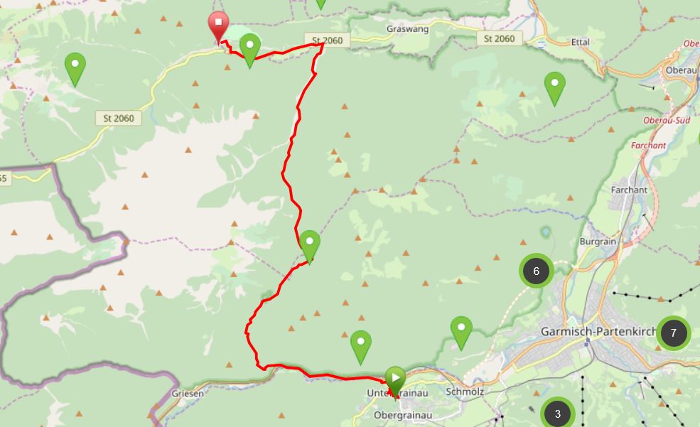
Map © www.ich-geh-wandern.de
Top hiking trail — experience the natural landscape of the Zugspitze region over 200 km
Not too long ago, the Spitzenwanderweg was ceremonially opened. The long-distance hiking trail covers 200 km and 12 stages through the picturesquely diverse landscape of the Zugspitze region. More than 6,800 meters of altitude difference are also covered, so the top hiking trail is quite a sporting endeavor. But it's worth it. Because the trail leads through a diverse landscape and also passes through numerous cultural monuments. The start and end point is the picturesque town of Murnau. Two overnight stays in huts are included on the long-distance hiking trail, once in the Soiern House and once in the Schachenhaus. On the 200 km, hikers pass fantastic views, flower-rich mountain and moor meadows, deep blue mountain lakes, bubbling springs and rivers, the spectacular Partnach and Höllental gorge, foothills of the Alps with far-reaching views, as well as cultural monuments such as the royal castles of Schachen and Linderhof Castle, as well as typical Bavarian villages such as Murnau, Krün, Mittenwald, Grainau or Oberammergau. There is therefore much to experience and discover on the 200 km long trail.
And we too are keen on the long-distance hiking trail and are treading this stage by stage, because the trail will also be a special experience for us locals. I will walk the path partly alone, but also with my colleague. Join us on the hiking trail.
The top hiking trail: All stages at a glance
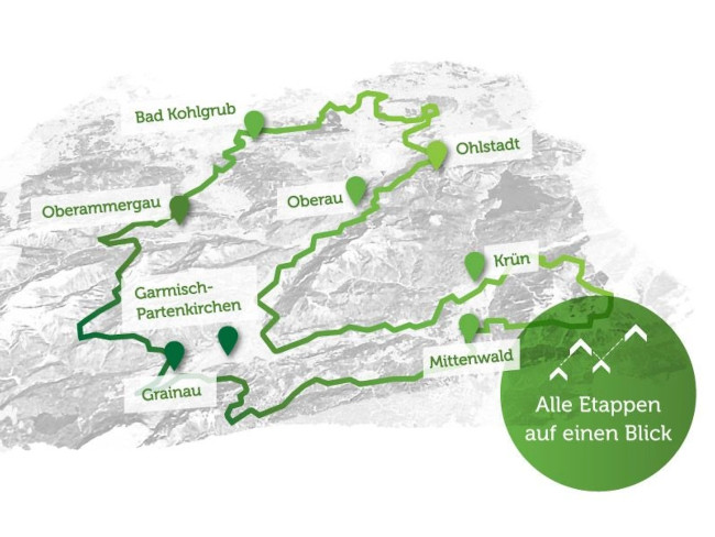
Picture © spitzenwanderweg.de
To stage 8: From Kreuzeck via Höllentalklamm to Grainau
Stage 9: From Grainau to Linderhof Castle
“You conquer the landscape with the soles of your shoes, not with the car tires. ”
Georges Duhamel, French writer, 1884 — 1966
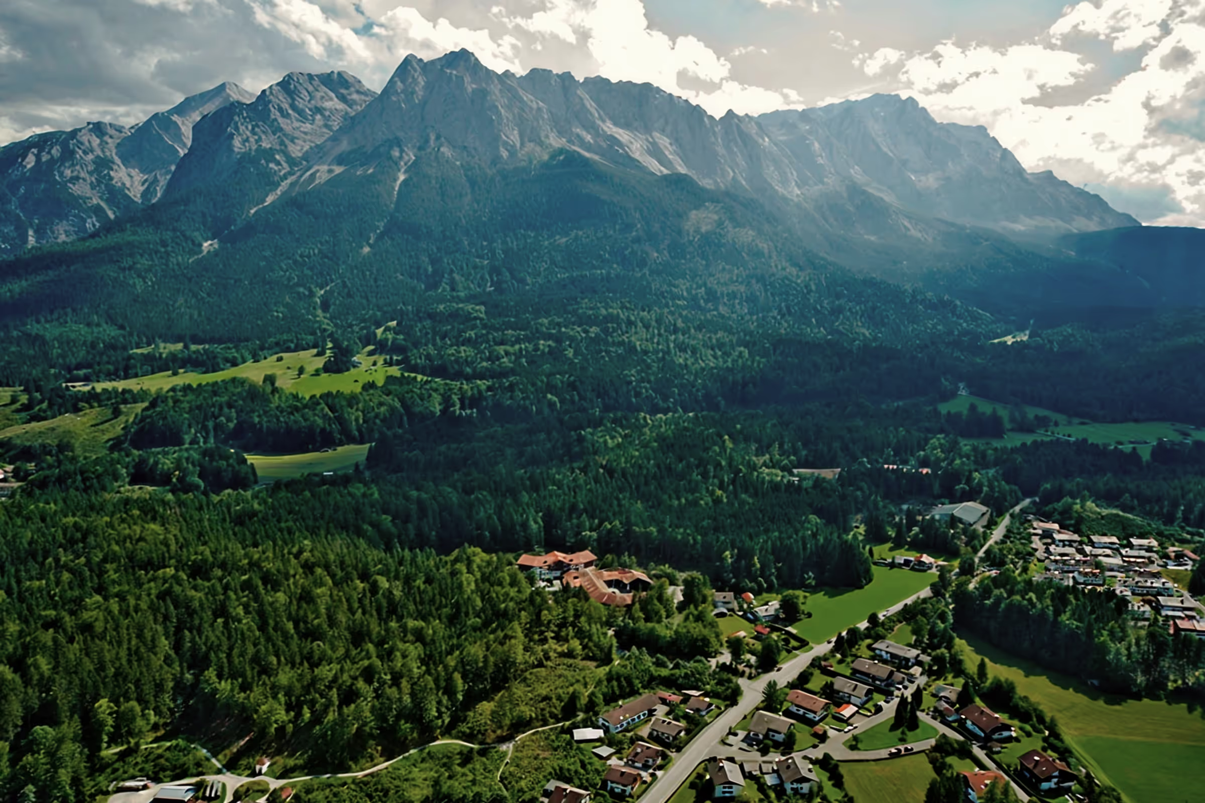
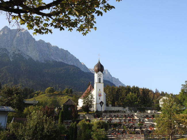
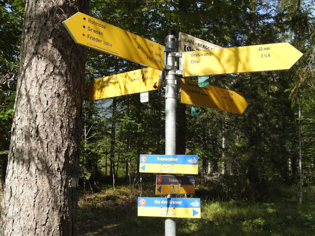
From the picturesque church of St. John the Baptist with the idyllic cemetery and the picturesque mountain scenery, I am starting today on the 9th stage of the peak hiking trail. On the beautiful hiking day, I am traveling alone this time. Through the city center of Grainau, the trail leads me first to the small chapel and then to the Baderseeweg, where I meet the sign of the peak hiking trail.
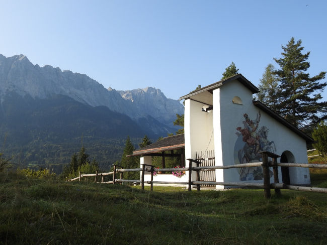
The top hiking trail behind Hotel Waxenstein takes me past a few picturesque farmhouses onto the Höhenrainweg and to the Kriegerkapelle, which I reach a short time later. The beautifully situated warrior band with air painting was built in 1957 and commemorates the many people from Grainau who died during the fighting of the Second World War. There are many benches here where you could sit and enjoy the view of the Zugspitze massif.
It continues across the pass that separates Grainau from the B23. From above, you can already hear the cars passing by and after the descent I hit the main road to Austria. I am now also following the path towards Griesen. Unfortunately, this section of the hiking trail is not very nice, but to get on the footpath to Linderhof at the end, you first have to follow the B23. The Loisach flows on my left, too bad that there is no path that runs in nature on the other side of the river. First deep below me, the course of the river will soon reach my height. If you feel like it, you could now take a cool bath in some parts of the river or at least keep your feet in the water. You can also often see kayakers at this point.

I reach the point where I now cross the B23 to get on the hiking/bike trail that leads to Linderhof Castle. The intersection is in front of the Ochsenhütte car park. From here I go back into nature and I soon leave the sounds of the cars behind me. Instead, I am accompanied by the ringing of cowbells grazing in the meadows.

I walk on the smaller forest path that runs above the larger forest road. It's uphill from here. At the end, the smaller forest trail comes back onto the larger forest road and it's time to continue uphill until you finally reach the height from which the trail will only run downhill. But first, it's time for a first break, a little refreshment and something to drink for the big part of the climb that lies ahead of me.

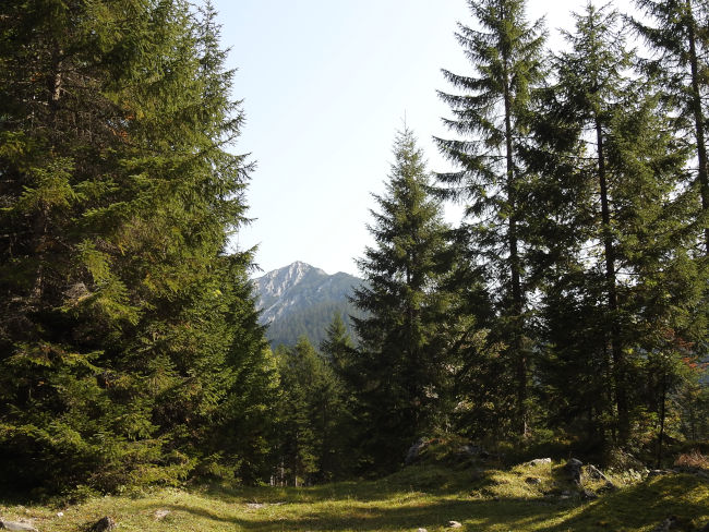
Strengthened well, it is now time for me to climb the altitude. The beautiful mountain forest offers pleasant shade in sunny temperatures, because with the climb, it also gets warmer for me than it already is. From time to time, there are some beautiful views of the surrounding mountains. Mountain bike and e-bike riders pass me by. Mountain bikers are also pedaling hard and the muscles of both hikers and bikers get moving. Fortunately, every climb also comes to an end and I have to admit that this increase wasn't as bad as initially assumed. It took me almost only 30 minutes to get up to the top.
I reach a large fork in the road where you can choose to walk or ride on various hiking trails or cycle paths. For me, it continues straight ahead. According to the hiking sign, I still have 2 hours 45 minutes to go before I finally reach Linderhof Castle. But since it's downhill from now on, the hardest part of the hike is a thing of the past and the rest will probably be more comfortable.
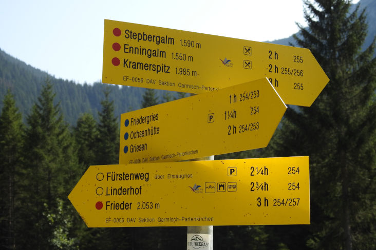
It continues on a wide forest road through the mountain forest. Again and again I also meet some cyclists and mountain hikers who ask me for directions. I can help most cyclists because they ask about the bike path to Griesen or the big turn-off from which I came. As for the mountain hiker who is looking for a branch up to a summit, I too am overwhelmed. I saw a sign for Frieder, but I didn't see the sign for the mountain he was looking for. I hope he finds the right path. I, on the other hand, am now looking for a rest area for a second break, because at lunchtime my stomach starts to growl and a second snack would be good now. But benches along the way were not thought of. A pile of wood also falls flat, as too many cows have left their legacies here. So I'm using a hunter's stand. It not only offers a beautiful elevated view, but also a nice seat.

With a nice view, the sandwich always tasted better. Ready for the last stretch of the road, I climb down from my high altitude. Straight ahead, it continues down towards Linderhof. Small streams ripple next to me, butterflies and bees search for nectar on the last flowers that are still blooming and the birdsong provides musical entertainment along the way. The mountains rise above the treetops, and some mountaineers and climbers will also pursue their passion here today.
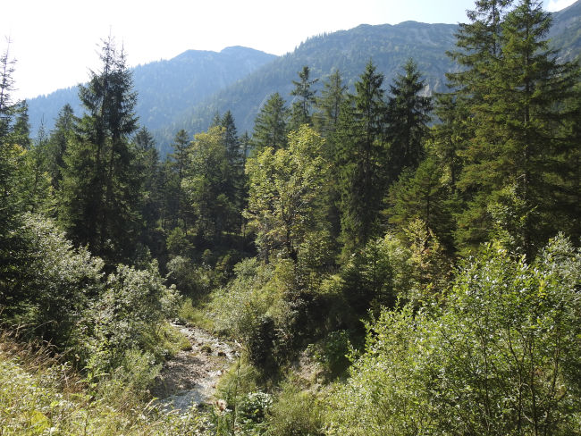
The deeper I get back into the valley, the more the forest widens. I pass wide streams that do not carry water due to the drought, but are filled to the brim with raging water when snow melts in winter or after heavy rains. Then I reach another fork in the road with a sign tree. There are two trails to Linderhof Castle, one of which takes 1 hour 15 minutes to walk, the other just an hour. Fortunately, the peak hiking trail sign points to the trail, which only takes 1 hour. So it means turning left for me.
The hiking trail runs across the dry course of the river, it's good that no water is flowing in it right now, otherwise the crossing would be a lot more tricky. On the other side, it goes back into the forest and continues on a wide forest road. I can now hear the cars on the road leading to Linderhof Castle. My further route takes me parallel to the road, but still through the countryside. I was already afraid that the path would lead directly along the road, as was the case with the B23 before. It's not far off now. A short way and I'm already standing on the road, which I have to cross briefly. A few more meters and I've arrived at Linderhof Castle.

Since I've already admired the castle from the inside, it's enough to take a tour of the park until my bus arrives and takes me back to Grainau. First, I buy an ice cream at the kiosk, which I've now really earned after traveling 20.5 km. Even today, many visitors come here to see the fairytale castle. Linderhof Castle may be King Ludwig II's smallest castle, but it was also his favorite castle. The garden area in which the neo-coco style pleasure palace built between 1870 and 1886 is located is huge and you could enjoy very long walks here. Many of the royal buildings in the park are also freely accessible and visitors receive information about their origin and significance in several languages via an intercom system.
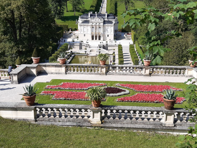
After taking a short tour through the gardens and enjoying the sun and the ambiance of the cascades in front of the castle for a few minutes, it's time to walk back to the entrance, because the bus is coming in a few minutes. The journey back to Grainau is quite long due to two transfers and waiting time, but my feet can rest in peace and quiet from the exertions.
Tips & info:
- Route length: 20.5 km, performance kilometers: 26 km
- Walking time without a break: approx. 5 hours 11 minutes
- Difficult hike (The website says difficult, but I would rather describe this tour as easy — moderate. Apart from its length, the trail poses no real difficulties, as it is wide, sure-footedness or a head for heights is not necessary). Comfortable hiking boots or running shoes for the route, usually wide forest trail, tar and dirt road.
- Unfortunately, the tourist office only provides an overview map of the Spitzenwanderweg. There is also no digital trail map on the official Spitzenwanderweg website. The best navigation is here.
- From the Hotel am Badersee, you don't necessarily have to walk down to the town of Grainau, but can turn right up to the road in front of and at Hotel Waxenstein.
- Public transport from Linderhof Castle: Take the bus to Ettal or Oberammergau. Change to the bus to Garmisch-Partenkirchen and take the Eibsee bus back to the hotel on Lake Badersee. The journey time is between 1 hour 50 and 2 hours 50 due to waiting times for transfers. The last bus leaves at 18:56 during the week (arrival hotel at 21:47), on Saturday and Sunday at 17:55 (arrival hotel at 20:47). Timetables at bahn.de
- This stage is also ideal for an e-bike or MTB tour. There is an e-bike charging station at the hotel at Linderhof Castle when it is open. Please check first.
- Places to stop for refreshments: first at Linderhof Castle. Therefore, bring enough food and drinks.
- Hiking signs are available, some of the Zugspitze sign can be seen small on the official yellow hiking signs. Therefore pay attention to the yellow hiking signs.
- Visit to Linderhof Castle: guided tours only, online ticket reservation in advance. In most cases, the castle still has a few remaining tickets, especially in the off-season. If you want to be sure, you should reserve tickets online for the afternoon viewing at least 7 days in advance. The castle park is freely accessible and free of charge. Information & tickets can be found here.
Heartily Wellcome
at Lake Badersee